IMAGES TAKEN NEAR TO
Garwed Gardens, NEATH, SA11 4EA
Introduction
This page details the photographs taken nearby to Garwed Gardens, SA11 4EA by members of the Geograph project.
The Geograph project started in 2005 with the aim of publishing, organising and preserving representative images for every square kilometre of Great Britain, Ireland and the Isle of Man.

There are currently over 7.5m images from over14,400 individuals and you can help contribute to the project by visiting https://www.geograph.org.uk
Image Map (Loading...)


Getting Data...Please wait
Leaflet Map data © OpenStreetMap
Images are licensed for reuse under creativecommons.org/licenses/by-sa/2.0
Notes
- Clicking on the map will re-center to the selected point.
- The higher the marker number, the further away the image location is from the centre of the postcode.
Image Listing (5 Images Found)
Images are licensed for reuse under creativecommons.org/licenses/by-sa/2.0
Image
Details
Distance
2
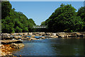
Weir and footbridge on the River Neath at Abergarwed
High summer often means low water conditions on the River Neath. The 'red water' in the left foreground is part of the legacy from the many underground coalmines in the area.
Image: © Cedwyn Davies
Taken: 13 Jul 2006
0.07 miles
3
Abergarwed upper lock
Remains of Abergarwed upper lock on the Neath Canal.
Image: © David Tyers
Taken: 24 Jun 2017
0.07 miles
4
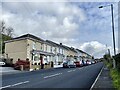
Neath Road
Row of terraced houses in Abergarwed.
Image: © Alan Hughes
Taken: 7 Oct 2020
0.10 miles
5
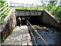
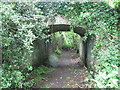
Dan yr A465 / Under the A465
Llwybr cyhoeddus yn mynd o dan yr A465. Enw'r ffrwd yw Nant Melin Cwrt.
A public footpath going under the A465. The name of the watercourse is Melin Court Brook.
Image: © Alan Richards
Taken: 14 Jun 2015
0.18 miles