IMAGES TAKEN NEAR TO
Clyne, NEATH, SA11 4BN
Introduction
This page details the photographs taken nearby to SA11 4BN by members of the Geograph project.
The Geograph project started in 2005 with the aim of publishing, organising and preserving representative images for every square kilometre of Great Britain, Ireland and the Isle of Man.

There are currently over 7.5m images from over14,400 individuals and you can help contribute to the project by visiting https://www.geograph.org.uk
Image Map (Loading...)


Getting Data...Please wait
Leaflet Map data © OpenStreetMap
Images are licensed for reuse under creativecommons.org/licenses/by-sa/2.0
Notes
- Clicking on the map will re-center to the selected point.
- The higher the marker number, the further away the image location is from the centre of the postcode.
Image Listing (39 Images Found)
Images are licensed for reuse under creativecommons.org/licenses/by-sa/2.0
Image
Details
Distance
1
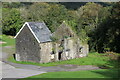
Derelict house, Ynys-dwfnant Farm
Detached stone house, there is a large inhabited house to the left out of shot.
Image: © M J Roscoe
Taken: 10 Oct 2021
0.00 miles
2
View from a charter train - Passing Ynys Dwfnant
A 2018 rail tour visiting South Wales, mostly freight-only lines. This one is the former Vale of Neath Railway.
Image: © Nigel Thompson
Taken: 10 Mar 2018
0.01 miles
3
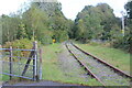
Railway line at level crossing
Little used line at crossing Image above Ynys-dwfnant Farm.
Image: © M J Roscoe
Taken: 10 Oct 2021
0.03 miles
4
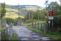
Open gates at level crossing, Ynys-dwfnant
Private crossing to riverside farm, Ynys-dwfnant Farm, on little used railway line Image
Image: © M J Roscoe
Taken: 10 Oct 2021
0.04 miles
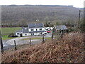
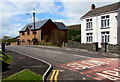
6
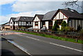
Modern houses, Clyne
Viewed across the B4434, here named Lletty Dafydd.
Image: © Jaggery
Taken: 29 Apr 2016
0.08 miles
7
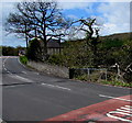
Road bridge over a brook, Clyne
The stone wall alongside the B4434 is at the edge of the bridge over Dyfnant,
a brook which is a minor tributary of the River Neath (Afon Nedd in Welsh).
Image: © Jaggery
Taken: 29 Apr 2016
0.08 miles
8
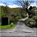
Junction of Lletty Dafydd and Dunvant Avenue, Clyne
This is the lanelike northern end of Dunvant Avenue,
a cul-de-sac extending for 100 metres from the B4434 Lletty Dafydd.
Image: © Jaggery
Taken: 29 Apr 2016
0.09 miles
9
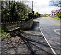
Roadside bench, Clyne
Alongside the B4434 Lletty Dafydd near a bus stop and shelter.
Image: © Jaggery
Taken: 29 Apr 2016
0.09 miles
10
Lletty Dafydd houses, Clyne
Viewed across the B4434 Lletty Dafydd from the corner of Llys Dyfnant. http://www.geograph.org.uk/photo/5199907
Image: © Jaggery
Taken: 29 Apr 2016
0.09 miles