IMAGES TAKEN NEAR TO
Henfaes Road, NEATH, SA11 3DX
Introduction
This page details the photographs taken nearby to Henfaes Road, SA11 3DX by members of the Geograph project.
The Geograph project started in 2005 with the aim of publishing, organising and preserving representative images for every square kilometre of Great Britain, Ireland and the Isle of Man.

There are currently over 7.5m images from over14,400 individuals and you can help contribute to the project by visiting https://www.geograph.org.uk
Image Map
Images are licensed for reuse under creativecommons.org/licenses/by-sa/2.0
Notes
- Clicking on the map will re-center to the selected point.
- The higher the marker number, the further away the image location is from the centre of the postcode.
Image Listing (69 Images Found)
Images are licensed for reuse under creativecommons.org/licenses/by-sa/2.0
Image
Details
Distance
1
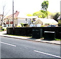
Two telecoms cabinets, Henfaes Road, Tonna
Viewed in May 2016. Only one cabinet was here in a Google Street View taken five years earlier.
Image: © Jaggery
Taken: 5 May 2016
0.01 miles
2
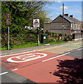
From 30 to 20 on Henfaes Road, Tonna
The speed limit on the B4434 Henfaes Road drops to 20mph on the approach to Tonnau Primary Community School. https://www.geograph.org.uk/photo/5076477 Though the village is usually known as Tonna in English, the Welsh Tonnau is part of the English name of the school known as Ysgol Gynradd Gymunedol Tonnau in Welsh.
Image: © Jaggery
Taken: 5 May 2016
0.02 miles
3
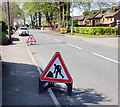
Temporary road signs, Henfaes Road, Tonna
Alongside the B4434 Henfaes Road on May 5th 2016.
Image: © Jaggery
Taken: 5 May 2016
0.02 miles
4
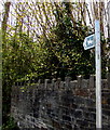
Quarry Road bridleway sign, Tonna
The sign on the corner of Henfaes Road points this https://www.geograph.org.uk/photo/6027085 way.
Image: © Jaggery
Taken: 5 May 2016
0.02 miles
5
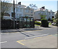
Henfaes Road bus stop and shelter, Tonna
This stop on the B4434 Henfaes Road is for buses to Neath.
Image: © Jaggery
Taken: 5 May 2016
0.02 miles
6
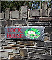
Lock House name sign and depiction, Tonna
On a stone wall facing Henfaes Road on the corner of the access
road descending to Lock House at the edge of the Neath Canal.
Image: © Jaggery
Taken: 5 May 2016
0.03 miles
7
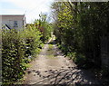
Quarry Road, Tonna
On the southeast side of Henfaes Road. A bridleway sign https://www.geograph.org.uk/photo/6027087 is near the camera.
Image: © Jaggery
Taken: 5 May 2016
0.03 miles
8
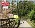
Caution - steep hill, beware oncoming vehicles, Tonna
The white on red sign is alongside the access road from Henfaes Road
to Lock House at the edge of the Neath Canal. The text is also in Welsh.
Image: © Jaggery
Taken: 5 May 2016
0.04 miles
9

Houses and hedges, Henfaes Road, Tonna
Viewed across the B4434 Henfaes Road.
Image: © Jaggery
Taken: 5 May 2016
0.04 miles
10
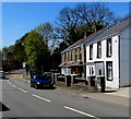
Four houses, Henfaes Road, Tonna
A detached house and a row of three houses viewed across the B4434 Henfaes Road.
Image: © Jaggery
Taken: 5 May 2016
0.04 miles