IMAGES TAKEN NEAR TO
Victoria Street, NEATH, SA11 2RB
Introduction
This page details the photographs taken nearby to Victoria Street, SA11 2RB by members of the Geograph project.
The Geograph project started in 2005 with the aim of publishing, organising and preserving representative images for every square kilometre of Great Britain, Ireland and the Isle of Man.

There are currently over 7.5m images from over14,400 individuals and you can help contribute to the project by visiting https://www.geograph.org.uk
Image Map (Loading...)


Getting Data...Please wait
Leaflet Map data © OpenStreetMap
Images are licensed for reuse under creativecommons.org/licenses/by-sa/2.0
Notes
- Clicking on the map will re-center to the selected point.
- The higher the marker number, the further away the image location is from the centre of the postcode.
Image Listing (48 Images Found)
Images are licensed for reuse under creativecommons.org/licenses/by-sa/2.0
Image
Details
Distance
1
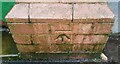
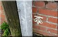
Ordnance Survey Cut Mark
This OS cut mark can be found on post south side of Regent Street. It marks a point 5.020m above mean sea level.
Image: © Adrian Dust
Taken: 6 Feb 2021
0.09 miles
2
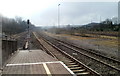
The view south from Briton Ferry railway station
The South Wales main line heads away from Briton Ferry station towards Port Talbot Parkway station. There is a minor station in between, Baglan, for local services.
Image: © Jaggery
Taken: 19 Feb 2011
0.09 miles
3
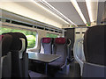
Interior of a class '800' train running between Paddington and Swansea
A 'first class' cabin, one of two in each of these 5 car units, which usually run in pairs to form a 10-car train
Image: © John Lucas
Taken: 2 Jun 2018
0.10 miles
5
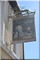
The Puddler's Arms
I thought that this pub was closed but maybe it isn't?
Image: © John M
Taken: 4 Apr 2015
0.12 miles
6

Puddle in mud, Rockingham Terrace, Briton Ferry
On February 14th 2024.
Image: © Jaggery
Taken: 14 Feb 2024
0.12 miles
7
Ordnance Survey Cut Mark
This OS cut mark can be found on the wall of Nos93 & 95 Shelone Road. It marks a point 13.119m above mean sea level.
Image: © Adrian Dust
Taken: 6 Feb 2021
0.12 miles
8

Long thin puddle, Rockingham Terrace, Briton Ferry
Near the southern end of Rockingham Terrace on February 14th 2024.
Image: © Jaggery
Taken: 14 Feb 2024
0.13 miles
9

Houses at the southern end of Rockingham Terrace, Briton Ferry
There are no houses on the camera side of the road.
Image: © Jaggery
Taken: 14 Feb 2024
0.13 miles
10

Rockingham Terrace houses south of Caroline Street, Briton Ferry
There are no houses on the camera side of the road.
Image: © Jaggery
Taken: 14 Feb 2024
0.13 miles