IMAGES TAKEN NEAR TO
Mansel Street, NEATH, SA11 2PD
Introduction
This page details the photographs taken nearby to Mansel Street, SA11 2PD by members of the Geograph project.
The Geograph project started in 2005 with the aim of publishing, organising and preserving representative images for every square kilometre of Great Britain, Ireland and the Isle of Man.

There are currently over 7.5m images from over14,400 individuals and you can help contribute to the project by visiting https://www.geograph.org.uk
Image Map
Images are licensed for reuse under creativecommons.org/licenses/by-sa/2.0
Notes
- Clicking on the map will re-center to the selected point.
- The higher the marker number, the further away the image location is from the centre of the postcode.
Image Listing (67 Images Found)
Images are licensed for reuse under creativecommons.org/licenses/by-sa/2.0
Image
Details
Distance
1
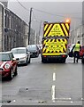
Your Recycling Crew At Work, Mansel Street, Briton Ferry
"YOUR RECYCLING CREW AT WORK" and the Welsh equivalent is on the back
of the lorry at work on a drizzly, misty day in February 2024.
Image: © Jaggery
Taken: 14 Feb 2024
0.03 miles
2
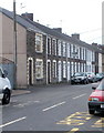
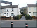
Hoo Street, Briton Ferry
Houses on the south side of Hoo Street view from the Neath Road (A474) end.
Image: © Jaggery
Taken: 19 Feb 2011
0.04 miles
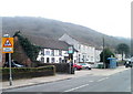
3
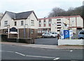
JK's Liberty Function Suite, Briton Ferry
Located at 222 Neath Road (A474), next to Chequers. http://www.geograph.org.uk/photo/2310686
The premises can accommodate functions for up to 200 people.
Image: © Jaggery
Taken: 19 Feb 2011
0.05 miles
4
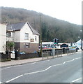
Chequers, Neath Road, Briton Ferry
At the date of this photograph, the use of these premises at 224 Neath Road was unclear. The sign hanging from the building shows Chequers, but research found that "Chequers Youth Club in Briton Ferry has been closed for a number of months" because of lack of funding. The letters YMCA are above the front door, but there is no mention of the premises on the YMCA website list of locations in South Wales.
Image: © Jaggery
Taken: 19 Feb 2011
0.05 miles
5
Neath Road entrance to Jersey Park, Briton Ferry
A sign in English and Welsh points across Neath Road (A474) to the entrance to Jersey Park. The public toilets are about 100 metres into the park.
Image: © Jaggery
Taken: 19 Feb 2011
0.05 miles
6
Monkey puzzle tree near entrance to Jersey Park, Briton Ferry
The tree, Araucaria araucana, or monkey puzzle tree, is in the garden of a house adjacent to the Neath Road (A474) arched gateway entrance http://www.geograph.org.uk/photo/2310666 to Jersey Park.
Image: © Jaggery
Taken: 19 Feb 2011
0.05 miles
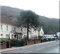
7
The Crown Inn, Briton Ferry
Pub at 244 Neath Road (A474). There is a 44-seat restaurant and a function room for up to 60 people.
Image: © Jaggery
Taken: 19 Feb 2011
0.05 miles
8
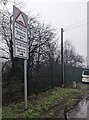
Humps warning sign, Rockingham Terrace, Briton Ferry
The sign facing Osterley Street shows humps for 440 yards to the left,
for 90 yards to the right. The text is also in Welsh.
Image: © Jaggery
Taken: 14 Feb 2024
0.08 miles
9
Osterley Street, Briton Ferry
Viewed from the Neath Road (A474) end looking past the railings of Ynysymaerdy Primary School.
Image: © Jaggery
Taken: 19 Feb 2011
0.09 miles
10
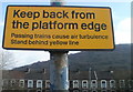
Keep back from the platform edge, Briton Ferry railway station
The lower half of the notice facing the platform states that
"Passing trains cause air turbulence
Stand behind yellow line" http://www.geograph.org.uk/photo/2310057
In the background are Rockingham Terrace houses.
Image: © Jaggery
Taken: 19 Feb 2011
0.09 miles