IMAGES TAKEN NEAR TO
Giants Grave Road, NEATH, SA11 2ND
Introduction
This page details the photographs taken nearby to Giants Grave Road, SA11 2ND by members of the Geograph project.
The Geograph project started in 2005 with the aim of publishing, organising and preserving representative images for every square kilometre of Great Britain, Ireland and the Isle of Man.

There are currently over 7.5m images from over14,400 individuals and you can help contribute to the project by visiting https://www.geograph.org.uk
Image Map (Loading...)


Getting Data...Please wait
Leaflet Map data © OpenStreetMap
Images are licensed for reuse under creativecommons.org/licenses/by-sa/2.0
Notes
- Clicking on the map will re-center to the selected point.
- The higher the marker number, the further away the image location is from the centre of the postcode.
Image Listing (49 Images Found)
Images are licensed for reuse under creativecommons.org/licenses/by-sa/2.0
Image
Details
Distance
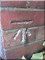
1
Ordnance Survey Cut Mark
This OS cut mark can be found on the wall of Nos93 & 95 Shelone Road. It marks a point 13.119m above mean sea level.
Image: © Adrian Dust
Taken: 6 Feb 2021
0.07 miles
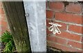
2
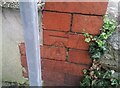
Ordnance Survey Cut Mark
This OS cut mark can be found on the brick post of No48 Giants Grave Road. It marks a point 23.893m above mean sea level.
Image: © Adrian Dust
Taken: 2 Nov 2014
0.13 miles
3
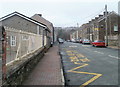
Osterley Street, Briton Ferry
Viewed from the Neath Road (A474) end looking past the railings of Ynysymaerdy Primary School.
Image: © Jaggery
Taken: 19 Feb 2011
0.14 miles
4
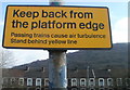
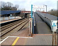
Keep back from the platform edge, Briton Ferry railway station
The lower half of the notice facing the platform states that
"Passing trains cause air turbulence
Stand behind yellow line" http://www.geograph.org.uk/photo/2310057
In the background are Rockingham Terrace houses.
Image: © Jaggery
Taken: 19 Feb 2011
0.14 miles
5
Access ramp, Briton Ferry railway station
Looking up the ramp towards Ynysymaerdy Road. A similar ramp on the left gives access to and from the other platform.
Image: © Jaggery
Taken: 19 Feb 2011
0.15 miles
6
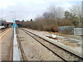
Side line, Briton Ferry railway station
A single railway line passes the eastern edge of a station platform.
There are several tracks on the western edge of the two passenger-service tracks through the station.
Image: © Jaggery
Taken: 19 Feb 2011
0.15 miles
7
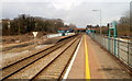
Briton Ferry railway station
The view north towards the Ynysymaerdy Road bridge.
Briton Ferry is an unstaffed station on the South Wales main line. The London Paddington to and from Swansea service does not stop here, but other services do, such as Cardiff Central to and from Milford Haven, and Manchester Piccadilly to and from Pembroke Dock.
The long yellow line is the one you must stand behind. http://www.geograph.org.uk/photo/2310025
Image: © Jaggery
Taken: 19 Feb 2011
0.15 miles
8
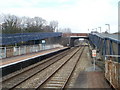
Ramps to Briton Ferry railway station
Ramps about 80 metres long connect the station with Ynysmaerdy Road.
Image: © Jaggery
Taken: 19 Feb 2011
0.15 miles
9
Ordnance Survey Cut Mark
This OS cut mark can be found on No7 Brynhyfryd Road. It marks a point 21.644m above mean sea level.
Image: © Adrian Dust
Taken: 6 Feb 2021
0.16 miles
10
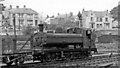
GW '6700' 0-6-0PT shunting at Briton Ferry
No. 6762 is one of the newer '6700' 0-6-0PTs. Built post-Nationalisation in 11/48, it lasted until 3/63. There were still extensive sidings at Briton Ferry in 1949.
Image: © Ben Brooksbank
Taken: 31 Aug 1949
0.17 miles