IMAGES TAKEN NEAR TO
Havard Jones Close, NEATH, SA11 2HR
Introduction
This page details the photographs taken nearby to Havard Jones Close, SA11 2HR by members of the Geograph project.
The Geograph project started in 2005 with the aim of publishing, organising and preserving representative images for every square kilometre of Great Britain, Ireland and the Isle of Man.

There are currently over 7.5m images from over14,400 individuals and you can help contribute to the project by visiting https://www.geograph.org.uk
Image Map (Loading...)


Getting Data...Please wait
Leaflet Map data © OpenStreetMap
Images are licensed for reuse under creativecommons.org/licenses/by-sa/2.0
Notes
- Clicking on the map will re-center to the selected point.
- The higher the marker number, the further away the image location is from the centre of the postcode.
Image Listing (20 Images Found)
Images are licensed for reuse under creativecommons.org/licenses/by-sa/2.0
Image
Details
Distance
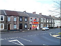
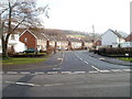
1
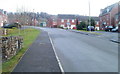
Penrhiwtyn Drive, Neath
Penrhiwtyn Drive climbs away from the junction with the A474.
Image: © Jaggery
Taken: 19 Feb 2011
0.03 miles
2
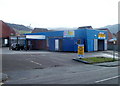
Brilliant Car Wash, Penrhiwtyn, Neath
Hand car wash and valeting service premises, on Pantyrheol near the Penrhiwtyn Drive junction. The site was formerly the Grandison Garage.
Image: © Jaggery
Taken: 19 Feb 2011
0.08 miles
3
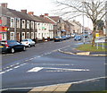
Southern boundary of Neath
The Penrhiwtyn name sign on the corner of Penrhiwtyn Drive and Pantyrheol (A474) marks the southern boundary of Neath. Behind the camera is Briton Ferry.
Image: © Jaggery
Taken: 19 Feb 2011
0.08 miles
4
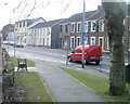
Northern boundary of Briton Ferry
An inconspicuous sign on the left marks the northern boundary of Briton Ferry (Llansawel in Welsh). The road is the A474, here named Pantyrheol (also spelt Pant-yr-heol). Viewed from the southern edge of Neath.
Image: © Jaggery
Taken: 19 Feb 2011
0.08 miles
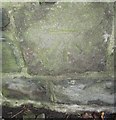
6
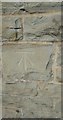
Ordnance Survey Cut Mark
This OS cut mark can be found on the front of St Thomas Chapel of Rest. It marks a point 7.419m above mean sea level.
Image: © Adrian Dust
Taken: 23 Aug 2016
0.12 miles
7
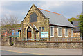
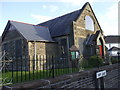
Bethesda Church, Court Sart
Congregational church, Court Sart near Briton Ferry.
Image: © Wayland Smith
Taken: 21 Apr 2014
0.12 miles
8
Conspicuous convenience store, Pantyrheol, Neath
A colourful Sheena convenience store and off-licence, at 139 Pantyrheol, stands out in the midst of the greys of the surrounding houses.
Image: © Jaggery
Taken: 19 Feb 2011
0.14 miles
9
Ordnance Survey Cut Mark
This OS cut mark can be found on the east side of Old Road. It marks a point 34.004m above mean sea level.
Image: © Adrian Dust
Taken: 23 Aug 2016
0.14 miles
10
Tyla Road, Briton Ferry
Viewed from the corner of the A474, here named Cwrt Sart.
Image: © Jaggery
Taken: 19 Feb 2011
0.16 miles