IMAGES TAKEN NEAR TO
Cuthbertson Street, NEATH, SA11 2HF
Introduction
This page details the photographs taken nearby to Cuthbertson Street, SA11 2HF by members of the Geograph project.
The Geograph project started in 2005 with the aim of publishing, organising and preserving representative images for every square kilometre of Great Britain, Ireland and the Isle of Man.

There are currently over 7.5m images from over14,400 individuals and you can help contribute to the project by visiting https://www.geograph.org.uk
Image Map (Loading...)


Getting Data...Please wait
Leaflet Map data © OpenStreetMap
Images are licensed for reuse under creativecommons.org/licenses/by-sa/2.0
Notes
- Clicking on the map will re-center to the selected point.
- The higher the marker number, the further away the image location is from the centre of the postcode.
Image Listing (14 Images Found)
Images are licensed for reuse under creativecommons.org/licenses/by-sa/2.0
Image
Details
Distance
1
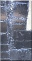
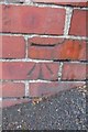
Ordnance Survey Cut Mark
This OS cut mark can be found on the north face of No75 Neath Road and the junction of Cuthbertson Street.
Image: © Adrian Dust
Taken: 23 Aug 2016
0.03 miles
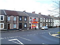
2
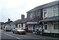
Noble Balti House, Penrhiwtyn, Neath
Balti takeaway on Pantyrheol Road, Neath, near the northern boundary of Briton Ferry.
Image: © Jaggery
Taken: 19 Feb 2011
0.08 miles
3
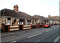
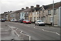
Bungalows, Pantyrheol, Penrhiwtyn, Neath
Bungalows on the west side of the A474, between Collins Street and Cuthbertson Street.
Image: © Jaggery
Taken: 19 Feb 2011
0.08 miles
4
Footbridge
The bridge crossing the main Swansea to London line has been condemned. It was used by football teams to access a playing field but now it's only a few locals walking their dogs who use it.
Image: © Alan Roberts
Taken: 10 Jun 2006
0.11 miles
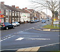
5
Pantyrheol, Penrhiwtyn, Neath
The A474 has various names along its route through the south part of Neath. Ahead, in the Penrhiwtyn area, it is named Pantyrheol.
Image: © Jaggery
Taken: 19 Feb 2011
0.11 miles
6
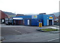
Brilliant Car Wash, Penrhiwtyn, Neath
Hand car wash and valeting service premises, on Pantyrheol near the Penrhiwtyn Drive junction. The site was formerly the Grandison Garage.
Image: © Jaggery
Taken: 19 Feb 2011
0.15 miles
7
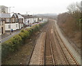
Neath : South Wales main line alongside the A474
Viewed from a footbridge. http://www.geograph.org.uk/photo/2283646
Briton Ferry station is about a mile (1600 metres) away.
Image: © Jaggery
Taken: 19 Feb 2011
0.17 miles
8
Ordnance Survey Cut Mark
This OS cut mark can be found at the junction of Westbourne Road. It marks a point 40.755m above mean sea level.
Image: © Adrian Dust
Taken: 23 Aug 2016
0.19 miles
9
Conspicuous convenience store, Pantyrheol, Neath
A colourful Sheena convenience store and off-licence, at 139 Pantyrheol, stands out in the midst of the greys of the surrounding houses.
Image: © Jaggery
Taken: 19 Feb 2011
0.21 miles
10
Southern boundary of Neath
The Penrhiwtyn name sign on the corner of Penrhiwtyn Drive and Pantyrheol (A474) marks the southern boundary of Neath. Behind the camera is Briton Ferry.
Image: © Jaggery
Taken: 19 Feb 2011
0.21 miles