IMAGES TAKEN NEAR TO
Evans Road, NEATH, SA11 2DB
Introduction
This page details the photographs taken nearby to Evans Road, SA11 2DB by members of the Geograph project.
The Geograph project started in 2005 with the aim of publishing, organising and preserving representative images for every square kilometre of Great Britain, Ireland and the Isle of Man.

There are currently over 7.5m images from over14,400 individuals and you can help contribute to the project by visiting https://www.geograph.org.uk
Image Map (Loading...)


Getting Data...Please wait
Leaflet Map data © OpenStreetMap
Images are licensed for reuse under creativecommons.org/licenses/by-sa/2.0
Notes
- Clicking on the map will re-center to the selected point.
- The higher the marker number, the further away the image location is from the centre of the postcode.
Image Listing (31 Images Found)
Images are licensed for reuse under creativecommons.org/licenses/by-sa/2.0
Image
Details
Distance
1
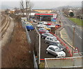
Railway, filling station and road, Melin Cryddan, Neath
The view east from a railway footbridge http://www.geograph.org.uk/photo/2283646
An Esso filling station is located between the South Wales main railway line and the A474, here named Mile End Row. In the foreground, a sign next to the school sign marks the boundary of the Melin Cryddan district of Neath.
Image: © Jaggery
Taken: 19 Feb 2011
0.06 miles
2

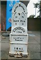
Milestone, Mile End Row, Neath
The milestone is at the edge of an Esso filling station on the A474, here named Mile End Row.
The inscription is
NEATH DISTRICT
TO NEATH 1
TO PYLE 11
LONDON 194
LANTWIT PARISH
1841
EAGLESBUSH FOUNDRY
Image: © Jaggery
Taken: 19 Feb 2011
0.06 miles
3
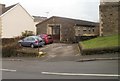
St Catherine's Church Hall, Neath
The church hall is on School Road, alongside the church. http://www.geograph.org.uk/photo/2283596
Image: © Jaggery
Taken: 19 Feb 2011
0.07 miles
4
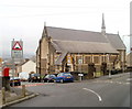
Church of St Catherine, Neath
Church in Wales church on the corner of School Road and Old Road, Melincryddan, Neath. Consecrated in 1891, the church is dedicated to Catherine of Alexandria whose symbolic Catherine Wheel is incorporated in the reredos (ornamental screen covering the wall at the back of the altar).
Image: © Jaggery
Taken: 19 Feb 2011
0.07 miles
5

TDH, Neath
Specialist plant & tool hire premises, Bush Row, viewed across Briton Ferry Road.
Image: © Jaggery
Taken: 19 Feb 2011
0.08 miles
6
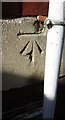
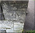
Ordnance Survey Cut Mark
This OS cut mark can be found on the front of Pencaerau School. It marks a point 21.741m above mean sea level.
Image: © Adrian Dust
Taken: 23 Aug 2016
0.08 miles
7
Old Milepost by the A474, Briton Ferry Road, Neath
Glamorgan Gothic casting by the A474, in parish of Neath (Neath, Port Talbot District), Briton Ferry Road, by Esso Service Station, The Hoar Stone.
Inscription reads:-
: TO / NEATH / 1 : : NEATH DISTRICT : : TO PYLE 11 : : LONDON / 194 / LANTWIT / PARISH / 1841 :
Maker:-
: EAGLESBUSH FOUNDRY :
Grade II listed by Cadw.
Reference Number: 11773 https://cadwpublic-api.azurewebsites.net/reports/listedbuilding/FullReport?lang=&id=11773
Surveyed
Milestone Society National ID: GLA_194PYNT11
Image: © Milestone Society
Taken: Unknown
0.08 miles
8

Petrol Station
Petrol Station on the A474 between Briton Ferry and Neath.
Image: © Alan Hughes
Taken: 14 Sep 2017
0.08 miles
9
Ordnance Survey Cut Mark
This OS cut mark can be found on the SW face of St Catherine's Church. It marks a point 21.278m above mean sea level.
Image: © Adrian Dust
Taken: 23 Aug 2016
0.10 miles
10
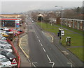
Mile End Row, Melin Cryddan, Neath
The view from a railway footbridge http://www.geograph.org.uk/photo/2283646 NE along the A474, here named Mile End Row.
Image: © Jaggery
Taken: 19 Feb 2011
0.10 miles