1
St Catherine's Church Hall, Neath
The church hall is on School Road, alongside the church. http://www.geograph.org.uk/photo/2283596
Image: © Jaggery
Taken: 19 Feb 2011
0.02 miles
2
Church of St Catherine, Neath
Church in Wales church on the corner of School Road and Old Road, Melincryddan, Neath. Consecrated in 1891, the church is dedicated to Catherine of Alexandria whose symbolic Catherine Wheel is incorporated in the reredos (ornamental screen covering the wall at the back of the altar).
Image: © Jaggery
Taken: 19 Feb 2011
0.02 miles
3
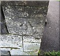
Ordnance Survey Cut Mark
This OS cut mark can be found on the SW face of St Catherine's Church. It marks a point 21.278m above mean sea level.
Image: © Adrian Dust
Taken: 23 Aug 2016
0.03 miles
4
Siloh Chapel, Neath
Congregational chapel on Old Road, Melincryddan, Neath. It was opened in 1880, built on land given by the Earl of Jersey in 1878.
Image: © Jaggery
Taken: 19 Feb 2011
0.05 miles
5
TDH, Neath
Specialist plant & tool hire premises, Bush Row, viewed across Briton Ferry Road.
Image: © Jaggery
Taken: 19 Feb 2011
0.11 miles
6
Ordnance Survey Rivet
This OS rivet can be found on the wall at the junction of Herbert Road. It marks a point 34.574m above mean sea level.
Image: © Adrian Dust
Taken: 10 Sep 2022
0.12 miles
7
Cryddan Brook emerges from a tunnel under Briton Ferry Road, Neath
The brook, spelt Cryddan or Crythan, after passing under Briton Ferry Road, flows around the edge of Castle Bingo. http://www.geograph.org.uk/photo/2283474
Image: © Jaggery
Taken: 19 Feb 2011
0.13 miles
8
Jasmine Spice, Neath
Takeaway at 135 Briton Ferry Road. A large sign on the side of the building will appeal to those who enjoy a challenge "ALL YOU CAN EAT BUFFET FROM £7.95"
The premises have had various occupiers in recent years, including The Olive Tree restaurant.
Image: © Jaggery
Taken: 19 Feb 2011
0.13 miles
9
Milestone, Mile End Row, Neath
The milestone is at the edge of an Esso filling station on the A474, here named Mile End Row.
The inscription is
NEATH DISTRICT
TO NEATH 1
TO PYLE 11
LONDON 194
LANTWIT PARISH
1841
EAGLESBUSH FOUNDRY
Image: © Jaggery
Taken: 19 Feb 2011
0.14 miles
10
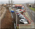
Railway, filling station and road, Melin Cryddan, Neath
The view east from a railway footbridge http://www.geograph.org.uk/photo/2283646
An Esso filling station is located between the South Wales main railway line and the A474, here named Mile End Row. In the foreground, a sign next to the school sign marks the boundary of the Melin Cryddan district of Neath.
Image: © Jaggery
Taken: 19 Feb 2011
0.14 miles


