IMAGES TAKEN NEAR TO
Riverside Drive, NEATH, SA11 1RX
Introduction
This page details the photographs taken nearby to Riverside Drive, SA11 1RX by members of the Geograph project.
The Geograph project started in 2005 with the aim of publishing, organising and preserving representative images for every square kilometre of Great Britain, Ireland and the Isle of Man.

There are currently over 7.5m images from over14,400 individuals and you can help contribute to the project by visiting https://www.geograph.org.uk
Image Map (Loading...)


Getting Data...Please wait
Leaflet Map data © OpenStreetMap
Images are licensed for reuse under creativecommons.org/licenses/by-sa/2.0
Notes
- Clicking on the map will re-center to the selected point.
- The higher the marker number, the further away the image location is from the centre of the postcode.
Image Listing (251 Images Found)
Images are licensed for reuse under creativecommons.org/licenses/by-sa/2.0
Image
Details
Distance
1
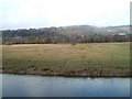
Neath Estuary Grazing Marsh
The north bank of the River Neath viewed from an observation area opposite the junction of Riverside Drive, Prince of Wales Drive and Parr Avenue. An information board in the observation area states:
"The view across the Neath Estuary of the grazing marsh may not be the prettiest landscape you have studied. However, grazing marshes have been lost to development and barrage schemes around the UK at such a rate that they are now considered a UK priority habitat and the Neath marsh is surprisingly the third largest relatively undamaged floodplain left in Wales."
Among the plants growing in the marsh are sea milkwort, sea aster, glasswort, English scurvygrass and lesser centaury. The birds and animals include goosanders, lapwings, reed buntings, mute swans, swallows and otters.
Image: © Jaggery
Taken: 19 Feb 2011
0.02 miles
2
Marker Post
National Cycle Network 47 post
Image: © Alan Roberts
Taken: 4 Aug 2005
0.02 miles
3
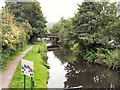
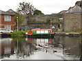
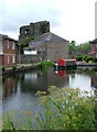
Neath Canal
The Neath Canal is a typical narrow Welsh Valley canal. It was opened in 1795 and runs from Briton Ferry on the estuary of the River Neath, to Glynneath. The canal is 13½ miles long.
Image: © David Dixon
Taken: 8 Sep 2011
0.03 miles
4
Neath Canal
The Neath Canal is a typical narrow Welsh Valley canal. It was opened in 1795 and runs from Briton Ferry on the estuary of the River Neath, to Glynneath. The canal is 13½ miles long.
Image: © David Dixon
Taken: 8 Sep 2011
0.03 miles
5
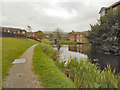
Castle Quay, Neath Canal
The Neath Canal is a typical narrow Welsh Valley canal. It was opened in 1795 and runs from Briton Ferry on the estuary of the River Neath, to Glynneath. The canal is 13½ miles long.
Image: © David Dixon
Taken: 8 Sep 2011
0.04 miles
6
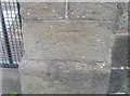
Ordnance Survey Cut Mark
This OS cut mark can be found on the gatepost of The Friends Meeting House. It marks a point 7.471m above mean sea level.
Image: © Adrian Dust
Taken: 6 Jun 2020
0.05 miles
7
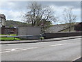
Riverside Drive electricity substation, Neath
Viewed across the B4434. The Western Power Distribution electricity substation identifier is RIVERSIDE DRIVE S/L NEATH S/S 562144, though a street name sign http://www.geograph.org.uk/photo/5251896 a few metres away shows PRINCE OF WALES DRIVE.
Image: © Jaggery
Taken: 3 May 2016
0.06 miles
8
Bilingual name sign Prince of Wales Drive/Rhodfa Tywysog Cymru, Neath
Facing the B4434.
Image: © Jaggery
Taken: 3 May 2016
0.06 miles
9
Friends Meeting House, Neath
From the towpath of Neath Canal with Neath Castle at the back.
Image: © Alan Roberts
Taken: 7 Jan 2003
0.06 miles
10
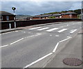
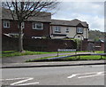
Zebra crossing, Prince of Wales Drive, Neath
Across the B4434 Prince of Wales Drive.
Image: © Jaggery
Taken: 3 May 2016
0.07 miles