IMAGES TAKEN NEAR TO
Church Place, NEATH, SA10 9DB
Introduction
This page details the photographs taken nearby to Church Place, SA10 9DB by members of the Geograph project.
The Geograph project started in 2005 with the aim of publishing, organising and preserving representative images for every square kilometre of Great Britain, Ireland and the Isle of Man.

There are currently over 7.5m images from over14,400 individuals and you can help contribute to the project by visiting https://www.geograph.org.uk
Image Map
Images are licensed for reuse under creativecommons.org/licenses/by-sa/2.0
Notes
- Clicking on the map will re-center to the selected point.
- The higher the marker number, the further away the image location is from the centre of the postcode.
Image Listing (117 Images Found)
Images are licensed for reuse under creativecommons.org/licenses/by-sa/2.0
Image
Details
Distance
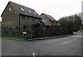
1
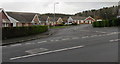
Church Place, Seven Sisters
Cul-de-sac of bungalows on the northeast side of the A4109 Church Road.
Image: © Jaggery
Taken: 15 Jan 2020
0.01 miles
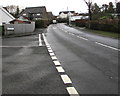
2
Church Road speed bumps, Seven Sisters
Bumps/humps across the A4109 Church Road on the ascent towards High Street.
Image: © Jaggery
Taken: 15 Jan 2020
0.03 miles
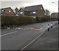
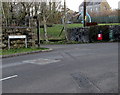
3
Junction of Church Road and Church Place, Seven Sisters
From the left, Church Place joins the A4109 Church Road. Ahead for High Street.
Image: © Jaggery
Taken: 15 Jan 2020
0.03 miles
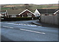
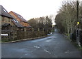
4

Bend in Church Road, Seven Sisters
The A4109 Church Road passes the Bryndulais Row junction and the Church Place junction.
Ahead for High Street Seven Sisters.
Image: © Jaggery
Taken: 15 Jan 2020
0.03 miles
5
Church Place bungalows, Seven Sisters
Viewed across the A4109 Church Road. Derived from a Hindi word meaning in the style of Bengal, bungalow was originally used in English for a lightly-built house, with a veranda and one storey. In current UK usage it is a convenient word for any one-storey dwelling.
Image: © Jaggery
Taken: 15 Jan 2020
0.03 miles
6
Clos y Sticlau houses, Seven Sisters
Viewed from a bend in the A4109 at the point where Church Road becomes High Street.
Image: © Jaggery
Taken: 15 Jan 2020
0.03 miles
7
Welsh-only name sign alongside the A4109, Seven Sisters
Clos y Sticlau does not have an equivalent English name.
Image: © Jaggery
Taken: 15 Jan 2020
0.04 miles
8
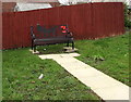
Soldier silhouettes black bench, Seven Sisters
Viewed in January 2020. Located on the right here https://www.geograph.org.uk/photo/6368643 on the east side of the village War Memorial, the metal bench has replaced the wooden bench seen in a May 2011 Google Street View.
Image: © Jaggery
Taken: 15 Jan 2020
0.04 miles
9
Clos y Sticlau, Seven Sisters
Dead-end road with a Welsh-only name viewed from the A4109 in January 2020.
A May 2011 Google Street View shows the houses under construction.
Image: © Jaggery
Taken: 15 Jan 2020
0.04 miles
10
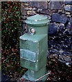
Hydrant alongside the A4109, Seven Sisters
The hydrant on the right https://www.geograph.org.uk/photo/6431704 here was made by Bayard, a waterworks equipment manufacturer founded in 1881 in the French city of Lyons where the company is still based today.
Image: © Jaggery
Taken: 15 Jan 2020
0.05 miles