IMAGES TAKEN NEAR TO
Woodland Road, NEATH, SA10 8RL
Introduction
This page details the photographs taken nearby to Woodland Road, SA10 8RL by members of the Geograph project.
The Geograph project started in 2005 with the aim of publishing, organising and preserving representative images for every square kilometre of Great Britain, Ireland and the Isle of Man.

There are currently over 7.5m images from over14,400 individuals and you can help contribute to the project by visiting https://www.geograph.org.uk
Image Map (Loading...)


Getting Data...Please wait
Leaflet Map data © OpenStreetMap
Images are licensed for reuse under creativecommons.org/licenses/by-sa/2.0
Notes
- Clicking on the map will re-center to the selected point.
- The higher the marker number, the further away the image location is from the centre of the postcode.
Image Listing (98 Images Found)
Images are licensed for reuse under creativecommons.org/licenses/by-sa/2.0
Image
Details
Distance
1
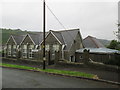
Infants School/Community Centre
There is an Ordnance Survey cut mark on the east face. http://www.geograph.org.uk/photo/4070913
Image: © Adrian Dust
Taken: 14 Jul 2014
0.09 miles
2
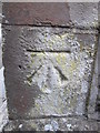
Ordnance Survey Cut Mark
This OS cut mark can be found on the east face of the Community Centre which was once the Infants School. It marks a point 108.277m above mean sea level. http://www.geograph.org.uk/photo/4070921
Image: © Adrian Dust
Taken: 14 Jul 2014
0.09 miles
3
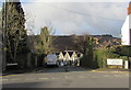
Woodland Road, Crynant
Woodland Road descends from the west side of the A4109 Main Road.
Crynant Community Centre is in the background.
Image: © Jaggery
Taken: 3 Jan 2020
0.10 miles
4
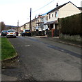
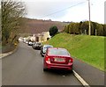
Woodland Road houses, Crynant
At the southern end of Woodland Road. Maes Mawr Road is behind the camera.
Image: © Jaggery
Taken: 3 Jan 2020
0.10 miles
5
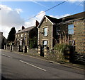
Main Road stone houses, Crynant
On the west side of the A4109 Main Road on the approach to the Woodland Road junction.
Image: © Jaggery
Taken: 3 Jan 2020
0.12 miles
6
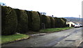
Evergreen southern end of Woodland Road, Crynant
Viewed on January 3rd 2020.
Image: © Jaggery
Taken: 3 Jan 2020
0.12 miles
7
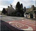
20 on Main Road, Crynant
A 20mph speed limit is in force on this part of the A4109 Main Road near a primary school.
Image: © Jaggery
Taken: 3 Jan 2020
0.12 miles
8
On-street parking, Maes Mawr Road, Crynant
Looking to the west down Maes Mawr Road past the grassy bank below Woodland Road.
Image: © Jaggery
Taken: 3 Jan 2020
0.12 miles
9
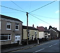
Wires over Main Road, Crynant
Wires radiate from the top of a post alongside the A4109 Main Road.
Image: © Jaggery
Taken: 3 Jan 2020
0.12 miles
10
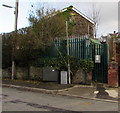
Electricity substation at the southern end of Woodland Road, Crynant
The Western Power Distribution electricity substation
is at the southern end of Woodland Road near Maes Mawr Road.
Image: © Jaggery
Taken: 3 Jan 2020
0.12 miles