IMAGES TAKEN NEAR TO
Main Road, NEATH, SA10 8PF
Introduction
This page details the photographs taken nearby to Main Road, SA10 8PF by members of the Geograph project.
The Geograph project started in 2005 with the aim of publishing, organising and preserving representative images for every square kilometre of Great Britain, Ireland and the Isle of Man.

There are currently over 7.5m images from over14,400 individuals and you can help contribute to the project by visiting https://www.geograph.org.uk
Image Map (Loading...)


Getting Data...Please wait
Leaflet Map data © OpenStreetMap
Images are licensed for reuse under creativecommons.org/licenses/by-sa/2.0
Notes
- Clicking on the map will re-center to the selected point.
- The higher the marker number, the further away the image location is from the centre of the postcode.
Image Listing (47 Images Found)
Images are licensed for reuse under creativecommons.org/licenses/by-sa/2.0
Image
Details
Distance
1
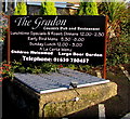
Information board for the Gradon, Crynant
On display on the north side of the Gradon https://www.geograph.org.uk/photo/6363950 on January 3rd 2020.
Image: © Jaggery
Taken: 3 Jan 2020
0.01 miles
2
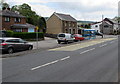
Main Road and side road, Crynant
The cars are parked in the side road on the east side of the A4109 Main Road.
Image: © Jaggery
Taken: 16 May 2016
0.02 miles
3
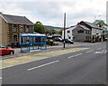
Blue bus shelter, Main Road, Crynant
On the east side of the A4109 Main Road, for buses towards Neath and Swansea.
The Gradon country pub and restaurant http://www.geograph.org.uk/photo/4952338 is on the right.
Image: © Jaggery
Taken: 16 May 2016
0.02 miles
4
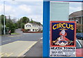
Circus poster on a Crynant bus shelter
Advertising Circus Mondao on a window of this http://www.geograph.org.uk/photo/4952444 shelter in mid May 2016.
Image: © Jaggery
Taken: 16 May 2016
0.02 miles
5
BT phonebox in Crynant
Set back from the east side of the A4109 Main Road.
Image: © Jaggery
Taken: 16 May 2016
0.02 miles
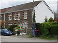
6
North side of The Gradon, 111 Main Road, Crynant
In January 2020 The Gradon nameboard shows
Country Pub and Restaurant - Fine Wines & Ales - Good Food Served Daily - A La Carte Menu.
KEEP CLEAR on the road surface is at the entrance to/exit from the pub car park.
Image: © Jaggery
Taken: 3 Jan 2020
0.02 miles
7
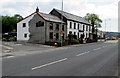
The Gradon, Crynant
Country pub and restaurant at 111 Main Road, Crynant.
Image: © Jaggery
Taken: 16 May 2016
0.03 miles
8
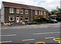
Row of four houses, Main Road, Crynant
On the east side of the A4109 Main Road, viewed from this http://www.geograph.org.uk/photo/4952479 bus stop.
Image: © Jaggery
Taken: 16 May 2016
0.03 miles
9
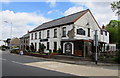
The Gradon, Crynant
Country pub and restaurant viewed across the A4109 Main Road, Crynant.
Image: © Jaggery
Taken: 16 May 2016
0.03 miles
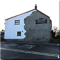
10
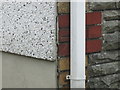
Ordnance Survey Cut Mark
This OS cut mark can be found on No125 Main Road. It marks a point 100.694m above mean sea level.
Image: © Adrian Dust
Taken: 14 Jul 2014
0.03 miles