IMAGES TAKEN NEAR TO
Main Road, NEATH, SA10 8NY
Introduction
This page details the photographs taken nearby to Main Road, SA10 8NY by members of the Geograph project.
The Geograph project started in 2005 with the aim of publishing, organising and preserving representative images for every square kilometre of Great Britain, Ireland and the Isle of Man.

There are currently over 7.5m images from over14,400 individuals and you can help contribute to the project by visiting https://www.geograph.org.uk
Image Map (Loading...)


Getting Data...Please wait
Leaflet Map data © OpenStreetMap
Images are licensed for reuse under creativecommons.org/licenses/by-sa/2.0
Notes
- Clicking on the map will re-center to the selected point.
- The higher the marker number, the further away the image location is from the centre of the postcode.
Image Listing (60 Images Found)
Images are licensed for reuse under creativecommons.org/licenses/by-sa/2.0
Image
Details
Distance
1
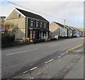
Semis on the west side of Main Road, Crynant
Semi-detached houses on the west side of the A4109 Main Road viewed from the corner of School Road.
Image: © Jaggery
Taken: 3 Jan 2020
0.02 miles
2
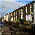
Main Road houses, Crynant
Stone houses on the east side of the A4109 Main Road.
Image: © Jaggery
Taken: 3 Jan 2020
0.03 miles
3
Stone bus shelter at the edge of Crynant Business Park
On the west side of the A4109 Main Road Crynant alongside a stop for northbound buses.
The stop on the camera side is for buses to Neath.
Image: © Jaggery
Taken: 3 Jan 2020
0.03 miles
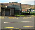
4
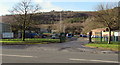
Crynant Business Park
Crynant Business Park, situated in the Neath valley,helps to bring much-needed employment to the area.
Image: © Alan Hughes
Taken: 25 Mar 2016
0.04 miles
5
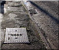
N.R.D.C. - a relic of Neath Rural District Council in the Main Road pavement, Crynant
Viewed in January 2020. The Archives Hub records that Neath Rural District Council was created under the provisions of the Local Government Act 1894. It comprised the parishes of Baglan Higher, Blaengwrach, Blaenhonddan, Clyne, Coed-ffranc, Dulais Lower, Dulais Higher, Dyffryn Clydach, Michaelston Higher, Neath Lower, Neath Higher, Resolven, Rhigos and Tonna. The Council comprised councillors and a chairman and initially replaced the local sanitary authorities. The Council was responsible for a range of local services including sanitation, sewerage, refuse collection, maintaining local roads, cemeteries and parks, licensing of public entertainments, water supply and housing. Rural District Councils were administered by committees and by appointed officers including a Clerk, Treasurer, Medical Officer of Health, Housing Officer and Surveyor. Neath Rural District Council was abolished in 1974 following local government reorganisation . Its functions were assumed by the new Borough of Neath.
Image: © Jaggery
Taken: 3 Jan 2020
0.04 miles
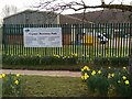
6
Entrance to Crynant Business Park
From the west side of the A4109 Main Road viewed in January 2020.
Crynant Business Park occupies part of the site of the former Treforgan Colliery.
Image: © Jaggery
Taken: 3 Jan 2020
0.05 miles
7
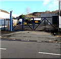
Locked gates at the entrance to vacant Main Road premises, Crynant
In January 2020 a notice on a gate states
We have moved to South Wales Fork Trucks, Pentreclwydau, Resolven.
Image: © Jaggery
Taken: 3 Jan 2020
0.05 miles
8
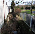
Unnamed stream below School Road, Crynant
A small tributary of the River Dulais.
Image: © Jaggery
Taken: 3 Jan 2020
0.05 miles
9
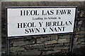
Mostly Welsh name sign on a Crynant corner
The sign on the corner of the A4109 Main Road shows that Heol Las Fawr https://www.geograph.org.uk/photo/6363975
leads to (Arwain At in Welsh) Heol y Berllan and Swn y Nant.
Image: © Jaggery
Taken: 3 Jan 2020
0.06 miles
10
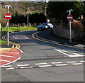
No Entry signs, School Road, Crynant
This is one of two junctions of the A4109 Main Road and School Road in Crynant.
The other one is 270 metres to the SSE. https://www.geograph.org.uk/photo/6362375
Image: © Jaggery
Taken: 3 Jan 2020
0.06 miles