IMAGES TAKEN NEAR TO
Birch Lane, NEATH, SA10 8LJ
Introduction
This page details the photographs taken nearby to Birch Lane, SA10 8LJ by members of the Geograph project.
The Geograph project started in 2005 with the aim of publishing, organising and preserving representative images for every square kilometre of Great Britain, Ireland and the Isle of Man.

There are currently over 7.5m images from over14,400 individuals and you can help contribute to the project by visiting https://www.geograph.org.uk
Image Map
Images are licensed for reuse under creativecommons.org/licenses/by-sa/2.0
Notes
- Clicking on the map will re-center to the selected point.
- The higher the marker number, the further away the image location is from the centre of the postcode.
Image Listing (13 Images Found)
Images are licensed for reuse under creativecommons.org/licenses/by-sa/2.0
Image
Details
Distance
1
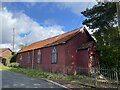
Red tin tabernacle, Cilfrew
Red painted corrugated iron clad chapel/school room with ‘ecclesiastic’ Gothic style fenestration and small entrance porch.
Image: © Alan Hughes
Taken: 8 Oct 2022
0.07 miles
2
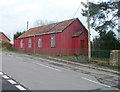
Red corrugated building, Cilfrew
There were no signs on the site to show the current use, if any, of this distinctive building on the east side of Main Road, Cilfrew, facing the northern edge of March Hywel. An old map shows 'Sunday School'. Pisgah Chapel http://www.geograph.org.uk/photo/2276925 is about 60 metres away on the other side of the road.
Image: © Jaggery
Taken: 19 Feb 2011
0.08 miles
3
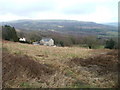
View from the edge of Hermon Chapel, Cilfrew
The view NE from the chapel http://www.geograph.org.uk/photo/2276885 looking towards Cilfrew Farm and the hills beyond.
Image: © Jaggery
Taken: 19 Feb 2011
0.08 miles
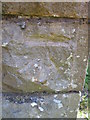
4
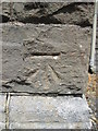
Ordnance Survey Cut Mark
This OS cut mark can be found on the SE angle of Pisgah Chapel. It marks a point 97.658m above mean sea level.
Image: © Adrian Dust
Taken: 18 May 2014
0.11 miles
5
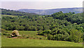
Eastward view past the site of Cilfrew station over Vale of Neath
The station had been in the nearer hollow and was on the ex-GW (Neath & Brecon Railway), closed 6/10/62, Neath being to the left, Colbren Junction and Brecon up the valley to the right. Further over is the Vale of Neath with the mountains beyond rising to Cefn Mawr (1,546 ft.) and Craig-y-Llyn (1,963 ft.).
Image: © Ben Brooksbank
Taken: 20 May 1990
0.13 miles
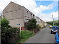
6
Road bridge at Cilfrew
Road bridge over Ty Draw brook at Cilfrew.
Image: © Alan Hughes
Taken: 1 Dec 2017
0.15 miles
7
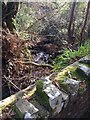
Tydraw Brook
View of Tydraw Brook from a bridge at Cilfrew.
Image: © Alan Hughes
Taken: 1 Dec 2017
0.15 miles
8
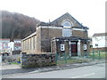
Pisgah Chapel, Cilfrew
Located on the west side of Main Road, Cilfrew, a village NE of Neath. The date shown on the window above the doorway is MCMXXX (1930).
Image: © Jaggery
Taken: 19 Feb 2011
0.16 miles
9
Ordnance Survey Cut Mark
This OS cut mark can be found on the west angle of Hermon Chapel. It marks a point 91.255m above mean sea level.
Image: © Adrian Dust
Taken: 18 May 2014
0.17 miles
10
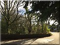
Llwybr New Road / New Road path
Llwybr cyhoeddus yn New Road, Cil-ffriw.
A public footpath at New Road, Cilfrew.
Image: © Alan Richards
Taken: 22 Jul 2016
0.19 miles