IMAGES TAKEN NEAR TO
Main Road, NEATH, SA10 8DA
Introduction
This page details the photographs taken nearby to Main Road, SA10 8DA by members of the Geograph project.
The Geograph project started in 2005 with the aim of publishing, organising and preserving representative images for every square kilometre of Great Britain, Ireland and the Isle of Man.

There are currently over 7.5m images from over14,400 individuals and you can help contribute to the project by visiting https://www.geograph.org.uk
Image Map (Loading...)


Getting Data...Please wait
Leaflet Map data © OpenStreetMap
Images are licensed for reuse under creativecommons.org/licenses/by-sa/2.0
Notes
- Clicking on the map will re-center to the selected point.
- The higher the marker number, the further away the image location is from the centre of the postcode.
Image Listing (33 Images Found)
Images are licensed for reuse under creativecommons.org/licenses/by-sa/2.0
Image
Details
Distance
1
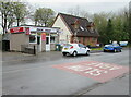
The Tuck Shop, Cadoxton-juxta-Neath
Viewed across the A4230 Main Road in May 2016.
Image: © Jaggery
Taken: 3 May 2016
0.02 miles
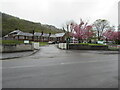
2
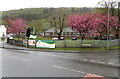
Pink blossom, Cadoxton-juxta-Neath
At the edge of Llangatwg Community School viewed across the A4230 Main Road in May 2016.
Image: © Jaggery
Taken: 3 May 2016
0.02 miles
3
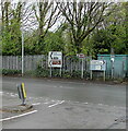
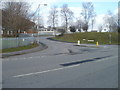
Directions at a junction in Cadoxton-juxta-Neath
Alongside the A4230 Main Road opposite the Penscynor junction.
Left for Neath and Merthyr. Right for Pontardawe.
Image: © Jaggery
Taken: 3 May 2016
0.03 miles
4
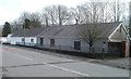
Cadoxton bungalows
Two semi-detached bungalows on the south side of Main Road (A4230), alongside the Tuck Shop. http://www.geograph.org.uk/photo/2276551
Image: © Jaggery
Taken: 19 Feb 2011
0.03 miles
5
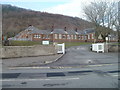
Entrance to Llangatwg Community School
The school entrance drive is on the north side of Main Road (A4230), opposite two semi-detached bungalows. http://www.geograph.org.uk/photo/2276709 Llangatwg Community School is the secondary school for the communities of the Neath and Dulais Valleys, and the villages of Cilfrew and Cadoxton.
Llangatwg is the Welsh name for Cadoxton. Both names derive from the parish church of Saint Catwg (Cadoc or Cadog in English), located in the centre of the village.
Image: © Jaggery
Taken: 19 Feb 2011
0.03 miles
6
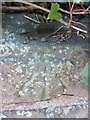
Ordnance Survey Rivet
This OS rivet can be found on the NE parapet of the railway bridge. It marks a point 22.973m above mean sea level.
Image: © Adrian Dust
Taken: 18 May 2014
0.04 miles
7
Into the Llangatwg Community School site, Cadoxton-juxta-Neath
From the A4230 Main Road. Entry only - a one-way system operates in the school site. A sign in the background shows a 5mph speed limit.
Image: © Jaggery
Taken: 3 May 2016
0.04 miles
8
The road to Cilfrew village
Penscynor, the road to Cilfrew, heads away from the A4230, Cadoxton, past Llangatwg Community School. http://www.geograph.org.uk/photo/2276710
Image: © Jaggery
Taken: 19 Feb 2011
0.04 miles
9
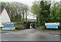
Minor road towards a railway bridge, Cadoxton-juxta-Neath
On the south side of the A4230 Main Road.
Betts Nurseries banners are on display in May 2016.
Image: © Jaggery
Taken: 3 May 2016
0.04 miles
10
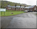
Llangatwg Community School, Cadoxton
Viewed across the A4230 Main Road in May 2016. Llangatwg is the Welsh name for Cadoxton (also known as Cadoxton-juxta Neath). Both names derive from the parish church of St Catwg (Cadoc or Cadog in English) in the centre of the village.
Image: © Jaggery
Taken: 3 May 2016
0.05 miles