IMAGES TAKEN NEAR TO
Bryncatwg, NEATH, SA10 8BG
Introduction
This page details the photographs taken nearby to Bryncatwg, SA10 8BG by members of the Geograph project.
The Geograph project started in 2005 with the aim of publishing, organising and preserving representative images for every square kilometre of Great Britain, Ireland and the Isle of Man.

There are currently over 7.5m images from over14,400 individuals and you can help contribute to the project by visiting https://www.geograph.org.uk
Image Map
Images are licensed for reuse under creativecommons.org/licenses/by-sa/2.0
Notes
- Clicking on the map will re-center to the selected point.
- The higher the marker number, the further away the image location is from the centre of the postcode.
Image Listing (51 Images Found)
Images are licensed for reuse under creativecommons.org/licenses/by-sa/2.0
Image
Details
Distance
1
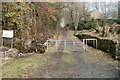
No motor cycles beyond this point, Craig Gwladus Country Park
On the path into the SW edge of Craig Gwladus Country Park http://www.geograph.org.uk/photo/2276354 a faded sign on the left states that no motor cycles are allowed beyond this point. The message is reinforced by a padlocked gate. Walkers can enter at the side.
Image: © Jaggery
Taken: 19 Feb 2011
0.08 miles
2
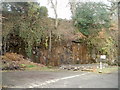
Rocky outcrop on the edge of Craig Gwladus Country Park
A constant trickle of water runs down the outcrop, near the SW edge of Craig Gwladus Country Park. http://www.geograph.org.uk/photo/2276354
Image: © Jaggery
Taken: 19 Feb 2011
0.08 miles
3
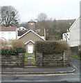
Ivy Cottage, Cadoxton, Neath
Set back from the north side of the A4230 Main Road. A tower is at the rear of the cottage.
Image: © Jaggery
Taken: 3 May 2016
0.11 miles
4
Tower in rear of cottage, Cadoxton
An unusual feature of Ivy Cottage http://www.geograph.org.uk/photo/2276374 is a tower built into the rear of the property.
Image: © Jaggery
Taken: 19 Feb 2011
0.11 miles
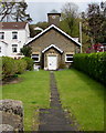
5
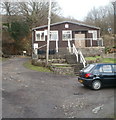
Scout hut, Cadoxton
The scout hut is set back from the north side of Main Road (A4230) Cadoxton, along a path into Craig Gwladus Country Park. http://www.geograph.org.uk/photo/2276354
Image: © Jaggery
Taken: 19 Feb 2011
0.11 miles
6
Cottage with a tower, Cadoxton
Viewed across Main Road (A4230). An unusual feature of Ivy Cottage is a tower built in to the rear of the property. http://www.geograph.org.uk/photo/2276493
The sign on the right states "NO WIDE HEAVY TRAFFIC INTO THE LANE".
Image: © Jaggery
Taken: 19 Feb 2011
0.11 miles
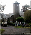
7
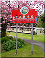
Catwg Primary School name sign, Main Road, Cadoxton, Neath
The sign shows that the Welsh name of the school is Ysgol Gynradd Catwg.
Image: © Jaggery
Taken: 3 May 2016
0.12 miles
8
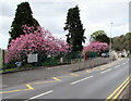
Pink blossom, Main Road, Cadoxton, Neath
Viewed across the A4230 Main Road on May 3rd 2016.
Image: © Jaggery
Taken: 3 May 2016
0.13 miles
9
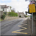
Zigzag markings on the A4230 Main Road, Cadoxton, Neath
Marking the Keep Clear Zone (no parking or stopping) outside Catwg Primary School.
Image: © Jaggery
Taken: 3 May 2016
0.13 miles
10
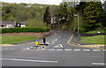
Junction of Main Road and Bryn Catwg, Cadoxton, Neath
The road named Bryn Catwg viewed across the A4230 Main Road.
Image: © Jaggery
Taken: 3 May 2016
0.13 miles