IMAGES TAKEN NEAR TO
Linden Close, NEATH, SA10 7UW
Introduction
This page details the photographs taken nearby to Linden Close, SA10 7UW by members of the Geograph project.
The Geograph project started in 2005 with the aim of publishing, organising and preserving representative images for every square kilometre of Great Britain, Ireland and the Isle of Man.

There are currently over 7.5m images from over14,400 individuals and you can help contribute to the project by visiting https://www.geograph.org.uk
Image Map
Images are licensed for reuse under creativecommons.org/licenses/by-sa/2.0
Notes
- Clicking on the map will re-center to the selected point.
- The higher the marker number, the further away the image location is from the centre of the postcode.
Image Listing (33 Images Found)
Images are licensed for reuse under creativecommons.org/licenses/by-sa/2.0
Image
Details
Distance
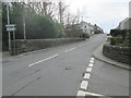
1
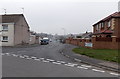
Southern end of Furzeland Drive, Bryncoch
Looking north along Furzeland Drive. Elias Road is on the left. Elias Drive is on the right.
Image: © Jaggery
Taken: 14 Mar 2014
0.10 miles
2
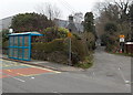
Blue bus shelter near a primary school, Bryncoch
Viewed across Main Road. The road on the right leads to an entrance to Bryncoch Church in Wales primary school.
Image: © Jaggery
Taken: 14 Mar 2014
0.11 miles
3
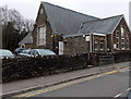
Bryncoch Community Centre
Viewed across Main Road.
Image: © Jaggery
Taken: 14 Mar 2014
0.12 miles
4
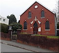
Saron Independent Chapel, Bryncoch
Viewed across Main Road. The chapel is the 1910 rebuild of the 1857 original.
Image: © Jaggery
Taken: 14 Mar 2014
0.12 miles
5
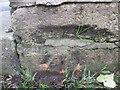
Ordnance Survey Cut Mark
This OS cut mark can be found on the wall of the old school. It marks a point 73.033m above mean sea level.
Image: © Adrian Dust
Taken: 15 Mar 2015
0.12 miles
6
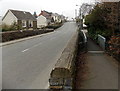
Footbridge alongside a road bridge in Bryncoch
The footbridge is on the east side of the bridge carrying Main Road
over a stream, a small tributary of the River Clydach.
Image: © Jaggery
Taken: 14 Mar 2014
0.14 miles
7
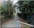
Path from Main Road to Dyffryn View, Bryncoch
The public footpath gives walkers a shortcut to houses at the southern end of Dyffryn View.
Image: © Jaggery
Taken: 14 Mar 2014
0.14 miles
9
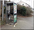
Dead phonebox in Bryncoch
Located alongside Main Road, opposite Heol Ty Gwyn. http://www.geograph.org.uk/photo/3899068
The handset and door have gone and only the frame of the coin box remains.
Image: © Jaggery
Taken: 14 Mar 2014
0.15 miles
10
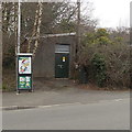
Main Road electricity substation in Bryncoch
Located opposite Heol Ty Gwyn. http://www.geograph.org.uk/photo/3899068
Image: © Jaggery
Taken: 14 Mar 2014
0.15 miles