IMAGES TAKEN NEAR TO
Rhiwlas, NEATH, SA10 7RB
Introduction
This page details the photographs taken nearby to Rhiwlas, SA10 7RB by members of the Geograph project.
The Geograph project started in 2005 with the aim of publishing, organising and preserving representative images for every square kilometre of Great Britain, Ireland and the Isle of Man.

There are currently over 7.5m images from over14,400 individuals and you can help contribute to the project by visiting https://www.geograph.org.uk
Image Map
Images are licensed for reuse under creativecommons.org/licenses/by-sa/2.0
Notes
- Clicking on the map will re-center to the selected point.
- The higher the marker number, the further away the image location is from the centre of the postcode.
Image Listing (6 Images Found)
Images are licensed for reuse under creativecommons.org/licenses/by-sa/2.0
Image
Details
Distance
1
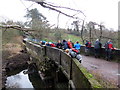
Hen gron / Old dam
Cerddwyr wrth hen gron a phont gyda hen beiriannau'r llifddorau.
Walkers at the former dam and bridge with the old sluice gates machinery.
Image: © Alan Richards
Taken: 17 Jan 2016
0.15 miles
2
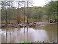
Duffryn Pond, Neath
Autumn after Heavy Rain
Image: © Gareth Davies
Taken: 6 Nov 2005
0.16 miles
3
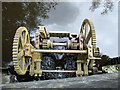
Machinery at Cwm Clydach pond
Machinery at the dam at Cwm Clydach pond. The dam was constructed in 1840 to ensure a constant supply of water for the water-wheels of the Neath Abbey Ironworks further downstream.
Image: © Robert Davies
Taken: 24 Aug 2008
0.17 miles
4
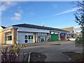
Shopping precinct
Local shops near Bryncoch.
Image: © Alan Hughes
Taken: 2 Jan 2019
0.17 miles
5
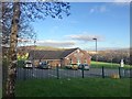
Community Centre
Owain Glyndwr Community Centre.
Image: © Alan Hughes
Taken: 2 Jan 2019
0.19 miles
6
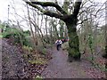
Llwybr ger Heol Taillwyd / Path near Taillwyd Road
Cerddwyr yn dilyn llwybr cyhoeddus tuag at Heol Taillwyd.
Walkers following a public footpath towards Taillwyd Road (trans. grey houses)
Image: © Alan Richards
Taken: 17 Jan 2016
0.20 miles