IMAGES TAKEN NEAR TO
Heol Esgyn, NEATH, SA10 7LL
Introduction
This page details the photographs taken nearby to Heol Esgyn, SA10 7LL by members of the Geograph project.
The Geograph project started in 2005 with the aim of publishing, organising and preserving representative images for every square kilometre of Great Britain, Ireland and the Isle of Man.

There are currently over 7.5m images from over14,400 individuals and you can help contribute to the project by visiting https://www.geograph.org.uk
Image Map
Images are licensed for reuse under creativecommons.org/licenses/by-sa/2.0
Notes
- Clicking on the map will re-center to the selected point.
- The higher the marker number, the further away the image location is from the centre of the postcode.
Image Listing (9 Images Found)
Images are licensed for reuse under creativecommons.org/licenses/by-sa/2.0
Image
Details
Distance
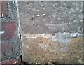
1
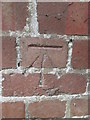
Ordnance Survey Cut Mark
This OS cut mark can be found on the wall of No83 Longford Road. It marks a point 39.682m above mean sea level.
Image: © Adrian Dust
Taken: 13 Jul 2014
0.09 miles
2
Ordnance Survey Cut Mark
This OS cut mark can be found on No63 Longford Road. It marks a point 38.457m above mean sea level.
Image: © Adrian Dust
Taken: 13 Jul 2014
0.11 miles
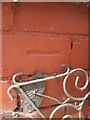
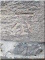
3
Ordnance Survey Cut Mark
This OS cut mark can be found on No16 Heol Penlan. It marks a point 67.044m above mean sea level.
Image: © Adrian Dust
Taken: 13 Oct 2020
0.12 miles
4
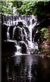
Falls on the River Clydach at Longford
These falls were formerly the site of a large waterwheel used to power the old Neath Abbey Ironworks that were situated below the falls.
Image: © Dai Bevan
Taken: Unknown
0.15 miles
5
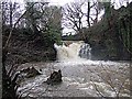
Falls on the Clydach
The falls on the river Clydach in full spate, the power that once drove the wheels of industry going to waste. The pool into which it falls was once known to older residents of the area as Pwll Ddu - (Black Pool).
Image: © Robert Davies
Taken: 15 Jan 2008
0.16 miles
6
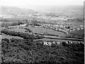
Eastward view
This view scanned from a print taken in the 1960s, shows in the foreground, Darran Woods and the row of houses at Penshanel. The fields between there and the village of Longford (centre of picture) have now been built on. Beyond Longford is Taillwyd, where the fields have again been replaced by houses. Towards the top centre of the picture is the Village of Caewern, and in the background the Neath Valley runs between the two sets of hills.
Image: © Dai Bevan
Taken: Unknown
0.19 miles
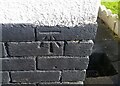
7
Ordnance Survey Cut Mark
This OS cut mark can be found to the west of Longford Road at the junction with side road. It marks a point 50.167m above mean sea level.
Image: © Adrian Dust
Taken: 13 Jul 2014
0.21 miles
8
Ordnance Survey Cut Mark
This OS cut mark can be found on the railway bridge, Longford Road. It marks a point 24.671m above mean sea level.
Image: © Adrian Dust
Taken: 12 Oct 2020
0.24 miles
9
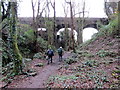
Pont Reilffordd / Railway Bridge
Cerddwyr yn dilyn llwybr tuag at bont reilffordd.
Walkers following a path towards a railway bridge.
Image: © Alan Richards
Taken: 17 Jan 2016
0.25 miles