IMAGES TAKEN NEAR TO
Springfield Road, NEATH, SA10 6UR
Introduction
This page details the photographs taken nearby to Springfield Road, SA10 6UR by members of the Geograph project.
The Geograph project started in 2005 with the aim of publishing, organising and preserving representative images for every square kilometre of Great Britain, Ireland and the Isle of Man.

There are currently over 7.5m images from over14,400 individuals and you can help contribute to the project by visiting https://www.geograph.org.uk
Image Map
Images are licensed for reuse under creativecommons.org/licenses/by-sa/2.0
Notes
- Clicking on the map will re-center to the selected point.
- The higher the marker number, the further away the image location is from the centre of the postcode.
Image Listing (117 Images Found)
Images are licensed for reuse under creativecommons.org/licenses/by-sa/2.0
Image
Details
Distance
1
Penbryn Road, Skewen
Viewed across New Road.
Image: © Jaggery
Taken: 5 Nov 2013
0.04 miles
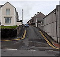
2
No entry to Caenant Terrace, Skewen
Most of Caenant Terrace is wide enough for two-way traffic, but this section,
viewed across New Road, is only about 2 metres wide, requiring a one-way system.
Image: © Jaggery
Taken: 5 Nov 2013
0.05 miles
3
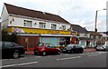
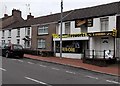
Jefferies Stores and Skewen Post Office
Skewen's post office is inside Jefferies Stores in New Road.
Image: © Jaggery
Taken: 5 Nov 2013
0.05 miles
4
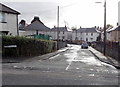
Jubilee Crescent, Skewen
Viewed across Dynevor Road. Jubilee Crescent is a cul-de-sac ending on the north side of railway lines.
Image: © Jaggery
Taken: 5 Nov 2013
0.07 miles
5
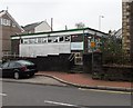
Fireworks shop in Skewen
The New Road shop faces Skewen Library. http://www.geograph.org.uk/photo/3782202
Image: © Jaggery
Taken: 5 Nov 2013
0.08 miles
6
Skewen Library
Viewed across New Road. Skewen Library is part of Neath Port Talbot County Borough Council's library service.
Image: © Jaggery
Taken: 5 Nov 2013
0.08 miles
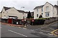
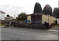
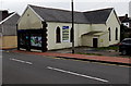
7
Salvation Army hall in Skewen
Viewed across Bethlehem Road.
Image: © Jaggery
Taken: 5 Nov 2013
0.08 miles
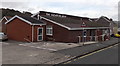
8
Community of Christ church, Skewen
Located on the south side of Dynevor Road, near the Jubilee Crescent junction. The Community of Christ was known until 2001 as the Reorganized Church of Jesus Christ of Latter Day Saints.
Image: © Jaggery
Taken: 5 Nov 2013
0.08 miles
9
The Sign Lab, Skewen
Located on the corner of New Road and Brook Street.
The Sign Lab's business is signs, posters, banners, stickers, van graphics etc.
Image: © Jaggery
Taken: 5 Nov 2013
0.09 miles
10
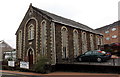
Horeb Baptist Chapel, Skewen
Built in 1868 with distinctively elongated windows and an elongated arched doorway.
Viewed across the A4230 New Road.
Image: © Jaggery
Taken: 5 Nov 2013
0.09 miles