IMAGES TAKEN NEAR TO
Ormes Road, NEATH, SA10 6TA
Introduction
This page details the photographs taken nearby to Ormes Road, SA10 6TA by members of the Geograph project.
The Geograph project started in 2005 with the aim of publishing, organising and preserving representative images for every square kilometre of Great Britain, Ireland and the Isle of Man.

There are currently over 7.5m images from over14,400 individuals and you can help contribute to the project by visiting https://www.geograph.org.uk
Image Map
Images are licensed for reuse under creativecommons.org/licenses/by-sa/2.0
Notes
- Clicking on the map will re-center to the selected point.
- The higher the marker number, the further away the image location is from the centre of the postcode.
Image Listing (52 Images Found)
Images are licensed for reuse under creativecommons.org/licenses/by-sa/2.0
Image
Details
Distance
1
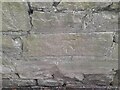
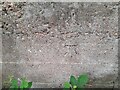
Ordnance Survey Cut Mark
This OS cut mark can be found on the wall south side of Drumau Road. It marks a point 105.153m above mean sea level.
Image: © Adrian Dust
Taken: 8 Jun 2022
0.05 miles
2
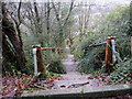
Llwybr i Heol Ormes / Path to Ormes Road
Llwybr yn gadael Heol Drumau ac yn arwain at Heol Ormes.
A path exiting Heol Drumau (trans. ridges) and heading towards Ormes Road.
Image: © Alan Richards
Taken: 17 Jan 2020
0.08 miles
3
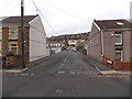
Grahams Terrace, Skewen
Looking towards Newell Road from Brookville Drive. Many references name the street Graham Terrace. The name sign on the right shows Grahams Terrace (Teras Graham in Welsh).
Image: © Jaggery
Taken: 28 Nov 2013
0.08 miles
4
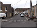
Woodland Road, Skewen
Looking north across Brookville Drive.
Image: © Jaggery
Taken: 28 Nov 2013
0.13 miles
5
Ordnance Survey Cut Mark
This OS cut mark can be found on the concrete retaining wall north side of Drumau Road. It marks a point 101.675m above mean sea level.
Image: © Adrian Dust
Taken: 8 Jun 2022
0.15 miles
6
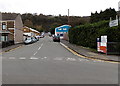
Access road to Lonlas Industrial Estate, Skewen
Viewed across the A4230 along Lucy Road towards the entrance http://www.geograph.org.uk/photo/3730831 to Lonlas Industrial Estate.
Image: © Jaggery
Taken: 5 Nov 2013
0.17 miles
7
Graig Road, Skewen
Looking north across Dynevor Place. The Travellers Well http://www.geograph.org.uk/photo/3730906 is on the left.
Image: © Jaggery
Taken: 5 Nov 2013
0.17 miles
8
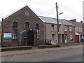
Skewen Community Church, Skewen
Viewed across Brookville Drive. The tablet shows SALEM APOSTOLIC CHURCH 1919.
Image: © Jaggery
Taken: 28 Nov 2013
0.18 miles
9
Design Printers in Skewen
The business premises are set back a few metres from the corner of Dynevor Road and Woodlands Close.
Image: © Jaggery
Taken: 5 Nov 2013
0.18 miles
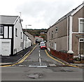
10
Brookville Drive, Skewen
Looking west from the corner of Woodland Road. http://www.geograph.org.uk/photo/3760183
Image: © Jaggery
Taken: 28 Nov 2013
0.18 miles