IMAGES TAKEN NEAR TO
Lon Y Grug, NEATH, SA10 6FW
Introduction
This page details the photographs taken nearby to Lon Y Grug, SA10 6FW by members of the Geograph project.
The Geograph project started in 2005 with the aim of publishing, organising and preserving representative images for every square kilometre of Great Britain, Ireland and the Isle of Man.

There are currently over 7.5m images from over14,400 individuals and you can help contribute to the project by visiting https://www.geograph.org.uk
Image Map
Images are licensed for reuse under creativecommons.org/licenses/by-sa/2.0
Notes
- Clicking on the map will re-center to the selected point.
- The higher the marker number, the further away the image location is from the centre of the postcode.
Image Listing (7 Images Found)
Images are licensed for reuse under creativecommons.org/licenses/by-sa/2.0
Image
Details
Distance
1
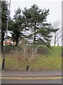
Coed Darcy
Stepiau sy'n cysylltu Heol Penygraig â The Ridgway ar ystad Coed Darcy. Mae'r tai yn cael eu hadeiladu ar safle hen burfa olew fawr.
Steps linking Penygraig Road with the Ridgway on the Coed Darcy estate. The houses are being built on a former large oil refinery.
Image: © Alan Richards
Taken: 3 Jan 2020
0.18 miles
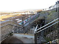
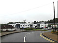
2
Canolfan Hyfforddu'r Gweilch / Osprey's Training Centre
Canolfan Hyfforddu Tîm Rhanbarthol y Gweilch yn Llandarcy.
Training facilities of the Osprey's Regional Rugby Team.
Image: © Alan Richards
Taken: 3 Jan 2020
0.22 miles
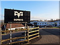
4
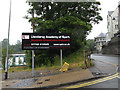
Llandarcy Academy of Sports sign
At the junction with Llandarcy Park
http://www.llandarcyacademy.com/
Image: © Geographer
Taken: 28 Jun 2015
0.22 miles
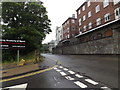
5
Entrance to Llandarcy Park
http://www.llandarcyacademy.com/
Image: © Geographer
Taken: 28 Jun 2015
0.22 miles
6
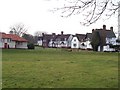
Llandarcy Village
Llandarcy Village was built to house workers for the nearby oil refinery
Image: © Steve Rigg
Taken: 5 Feb 2006
0.23 miles