IMAGES TAKEN NEAR TO
Cardonnel Road, NEATH, SA10 6DD
Introduction
This page details the photographs taken nearby to Cardonnel Road, SA10 6DD by members of the Geograph project.
The Geograph project started in 2005 with the aim of publishing, organising and preserving representative images for every square kilometre of Great Britain, Ireland and the Isle of Man.

There are currently over 7.5m images from over14,400 individuals and you can help contribute to the project by visiting https://www.geograph.org.uk
Image Map
Images are licensed for reuse under creativecommons.org/licenses/by-sa/2.0
Notes
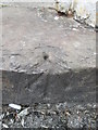
- Clicking on the map will re-center to the selected point.
- The higher the marker number, the further away the image location is from the centre of the postcode.
Image Listing (111 Images Found)
Images are licensed for reuse under creativecommons.org/licenses/by-sa/2.0
Image
Details
Distance
1
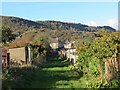
Llwybr ceffyl Sgiwen / Skewen Bridleway
Llwybr ceffyl yn Sgiwen. Y bryn yn y pellter yw Mynydd Drumau.
A bridleway in Skewen (poss. from Ynys Cuen i.e. meadow of the Cuen stream). The hill in the distance is known as Mynydd Drumau.
Image: © Alan Richards
Taken: 4 Nov 2013
0.03 miles
2
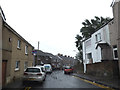
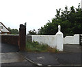
Cardonnel Road, Skewen
At the junction with the B4290 Burrows Road
Image: © Geographer
Taken: 28 Jun 2015
0.06 miles
3
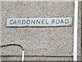
Cardonnel Road sign
On Cardonnel Road at the junction with the B4290 Burrows Road
Image: © Geographer
Taken: 28 Jun 2015
0.07 miles
4
B4290 Burrows Road, Skewen
At the junction with Cardonnel Road
Image: © Geographer
Taken: 28 Jun 2015
0.07 miles
5
Footpath to the B4290 Old Road
Off Castle Street at the junction with Cardonnel Road
Image: © Geographer
Taken: 28 Jun 2015
0.07 miles
6
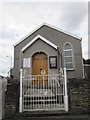
Presbyterian Chapel
There is an Ordnance Survey damaged rivet on the entrance step. http://www.geograph.org.uk/photo/4069147
Image: © Adrian Dust
Taken: 13 Jul 2014
0.07 miles
7
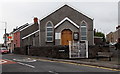
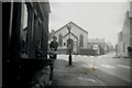
Y Capel, Skewen
Despite its Welsh name (Y Capel is The Chapel) this is a Presbyterian Church of Wales chapel where services are in English. Viewed across Burrows Road from the corner of Cardonnel Street.
Image: © Jaggery
Taken: 5 Nov 2013
0.07 miles
8
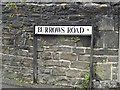
Burrows Road sign
On Burrows Road at the junction with Cardonnel Road near Y Capel Neath Port Talbot
Image: © Geographer
Taken: 28 Jun 2015
0.07 miles
9
Ordnance Survey Rivet
This damaged OS rivet can be found on the step of the Presbyterian Chapel. It marks a point 44.134m above mean sea level. http://www.geograph.org.uk/photo/4069152
Image: © Adrian Dust
Taken: 13 Jul 2014
0.07 miles
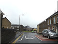
10
B4290 Old Road, Skewen
At the junction with Queens & Cardonnel Roads, the Chapel is in the distance
Image: © Geographer
Taken: Unknown
0.07 miles