IMAGES TAKEN NEAR TO
Pale Road, NEATH, SA10 6BP
Introduction
This page details the photographs taken nearby to Pale Road, SA10 6BP by members of the Geograph project.
The Geograph project started in 2005 with the aim of publishing, organising and preserving representative images for every square kilometre of Great Britain, Ireland and the Isle of Man.

There are currently over 7.5m images from over14,400 individuals and you can help contribute to the project by visiting https://www.geograph.org.uk
Image Map
Images are licensed for reuse under creativecommons.org/licenses/by-sa/2.0
Notes
- Clicking on the map will re-center to the selected point.
- The higher the marker number, the further away the image location is from the centre of the postcode.
Image Listing (28 Images Found)
Images are licensed for reuse under creativecommons.org/licenses/by-sa/2.0
Image
Details
Distance
1
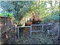
Llwybr troed Pentreffynnon footpath
Llwybr cyhoeddus yn ystad Pentreffynnon yn Sgiwen.
A public footpath in the Pentreffynnon estate in Skewen.
Image: © Alan Richards
Taken: 4 Nov 2013
0.11 miles
2
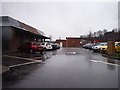
Neath Abbey : McDonald's Car Park
A car park beside the McDonald's here in Skewen.
Image: © Lewis Clarke
Taken: 2 Mar 2014
0.12 miles
3
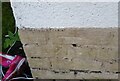
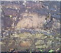
Ordnance Survey Cut Mark
This OS cut mark can be found on No1 Parc-y-Deri. It marks a point 40.974m above mean sea level.
Image: © Adrian Dust
Taken: 13 Oct 2020
0.12 miles
4
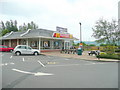
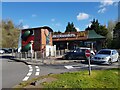
McDonald's, Neath
Just off the A465 eastbound about half a mile away from M4 Junction 43.
Yes it could be anywhere!
Image: © Jonathan Billinger
Taken: 10 Jun 2010
0.12 miles
5
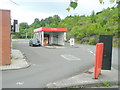
Car Wash, Vale of Neath services
Just off the A465 eastbound.
Image: © Jonathan Billinger
Taken: 10 Jun 2010
0.12 miles
6
McDonald's fast food off the A465 at Pen-yr-Heol
Image: © Jeff Gogarty
Taken: 9 Apr 2022
0.13 miles
7
Service Station on the A465 near Skewen, Neath
Image: © Jeff Gogarty
Taken: 4 Jun 2016
0.14 miles
8
Ordnance Survey Cut Mark
This OS cut mark can be found on the wall SE side of Burrows Road. It marks a point 47.188m above mean sea level.
Image: © Adrian Dust
Taken: 13 Oct 2020
0.15 miles
9
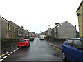
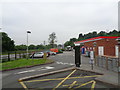
Bosworth Road, Skewen
At the junction with Cardonnel Road
Image: © Geographer
Taken: 28 Jun 2015
0.16 miles
10

The Tennant Canal under the A465
The Tennant Canal under the A465 dual carriageway near Skewen
Image: © Kevin Corcoran
Taken: 7 Mar 2015
0.16 miles