IMAGES TAKEN NEAR TO
Shirland Close, SHEFFIELD, S9 3SZ
Introduction
This page details the photographs taken nearby to Shirland Close, S9 3SZ by members of the Geograph project.
The Geograph project started in 2005 with the aim of publishing, organising and preserving representative images for every square kilometre of Great Britain, Ireland and the Isle of Man.

There are currently over 7.5m images from over14,400 individuals and you can help contribute to the project by visiting https://www.geograph.org.uk
Image Map (Loading...)


Getting Data...Please wait
Leaflet Map data © OpenStreetMap
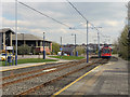
Images are licensed for reuse under creativecommons.org/licenses/by-sa/2.0
Notes
- Clicking on the map will re-center to the selected point.
- The higher the marker number, the further away the image location is from the centre of the postcode.
Image Listing (80 Images Found)
Images are licensed for reuse under creativecommons.org/licenses/by-sa/2.0
Image
Details
Distance
2
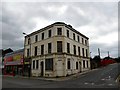
Disused building
This somewhat dilapidated building stands at the corner of the A6178 Attercliffe Road and Shirland Road. Could anyone tell me what its original use was and when it was built, please.
Image: © Bobby Clegg
Taken: 5 Jun 2012
0.09 miles
3
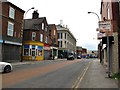
Attercliffe streetscape
Taken on the day of the Queen's Diamond Jubilee, this would account for the lack of traffic on the quiet bank holiday. Viewed from A6178 Attercliffe Road junction with Shirland Road and Baker Street.
Image: © Bobby Clegg
Taken: 5 Jun 2012
0.10 miles
4
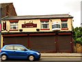
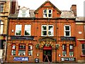
The King's Head
This pub, now awaiting new occupants, is located on A6178 Attercliffe Road SW of Church Lane on the opposite side of the road to the Don Valley Hotel.
Image: © Bobby Clegg
Taken: 5 Jun 2012
0.10 miles
5
The Don Valley Hotel
This building is located on A6178 Attercliffe Road SW of Church Lane.
Image: © Bobby Clegg
Taken: 5 Jun 2012
0.10 miles
6
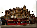
Zeenat Restaurant
This fine looking building at the junction of Attercliffe Road and Worksop Road is now occupied by an Indian cuisinerie. The architecture is late Victorian or Edwardian, although I am not sure what year. Can anybody please tell what its original use was, please. A bank, maybe.
Image: © Bobby Clegg
Taken: 5 Jun 2012
0.10 miles
7
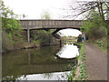
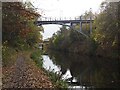
Waterways bridge
The principal bridge in this view carries Shirland Lane over the canal. In front of it is a narrower structure with Brithsh Waterways sign on it - perhaps carrying water to feed the canal?
Image: © Stephen Craven
Taken: 3 Apr 2012
0.11 miles
8
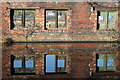
Dereliction on the canal
The reflections of derelict buildings on the Sheffield and Tinsley canal.
Image: © Dave Pickersgill
Taken: 5 Jan 2017
0.11 miles
9
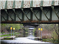
A Plethora of Bridges
There are no less than five bridges on this reach of the canal. The first is a railway bridge, then there is a road bridge, then a pedestrian bridge, a tram bridge and another road bridge. Image] is the reciprocal view.
Image: © Anne Burgess
Taken: 3 Apr 2012
0.12 miles
10
Supertram footbridge
Bridge #7B on the Sheffield & Tinsley Canal provides pedestrian access to the Attercliffe tram stop
Image: © Graham Hogg
Taken: 16 Nov 2020
0.12 miles