IMAGES TAKEN NEAR TO
Fife Way, SHEFFIELD, S9 1QB
Introduction
This page details the photographs taken nearby to Fife Way, S9 1QB by members of the Geograph project.
The Geograph project started in 2005 with the aim of publishing, organising and preserving representative images for every square kilometre of Great Britain, Ireland and the Isle of Man.

There are currently over 7.5m images from over14,400 individuals and you can help contribute to the project by visiting https://www.geograph.org.uk
Image Map
Images are licensed for reuse under creativecommons.org/licenses/by-sa/2.0
Notes
- Clicking on the map will re-center to the selected point.
- The higher the marker number, the further away the image location is from the centre of the postcode.
Image Listing (38 Images Found)
Images are licensed for reuse under creativecommons.org/licenses/by-sa/2.0
Image
Details
Distance
1
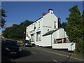
Wincobank Hotel, Wincobank, Sheffield
Junction of Newman Road and Merton Lane.
See http://www.geograph.org.uk/photo/1645462 for an alternative view.
Image: © JThomas
Taken: 27 Sep 2014
0.15 miles
2
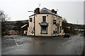
The Wincobank Hotel
A classic triangular corner pub. Now displaying a Thwaites sign, but would have been a Stone's, Ward's or Tetley's pub in the past.
Image: © David Lally
Taken: 2 Jan 2010
0.15 miles
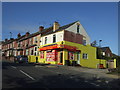
3
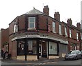
Hair and beauty salon on corner of Elm View Road and Fife Street
Image: © Neil Theasby
Taken: 30 Aug 2011
0.15 miles
5
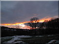
Sunset at Woolley wood, Wincobank
The obstacle course for bikes in the foreground is really popular though there is no sign of use in this shot. Just a pity that walks through the woodland sometimes involve getting out of the way of people illegally using it for motorbikes.
Image: © Nic Franklin-Woolley
Taken: 20 Dec 2009
0.16 miles
6
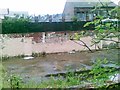
Site of former Community Centre, Low Wincobank
Image: © Alex McGregor
Taken: 8 Jun 2012
0.16 miles
7
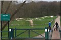
BMX Track, Low Wincobank, Sheffield
Two lads on their way to use the BMX Track ... Woolley Wood is in the background.
Image: © Terry Robinson
Taken: 30 Mar 2009
0.18 miles
8
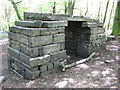
The Lost Gateway
'The Lost Gateway' is located near the Barrow Road entrance of Woolley Wood, an ancient woodland with a number of archaeological features. It was first documented in 1597 as ‘Woollywoodside.' The woodland was managed on a system of coppice with standards from the 16th century until the latter part of the 19th century, whereupon a system of ‘high forest’ was introduced, along with plantings of beech and hornbeam. The gateway is made from reclaimed stone and was recently constructed by Mick Humphries.
Image: © Dave Pickersgill
Taken: 16 May 2012
0.18 miles
9
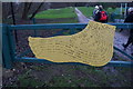
Giants Foot, Woolley Woods
Giants Foot, Woolley Woods. One of a number in the area.
Image: © Dave Pickersgill
Taken: 28 Mar 2013
0.19 miles