IMAGES TAKEN NEAR TO
Lincoln Street, SHEFFIELD, S9 1AU
Introduction
This page details the photographs taken nearby to Lincoln Street, S9 1AU by members of the Geograph project.
The Geograph project started in 2005 with the aim of publishing, organising and preserving representative images for every square kilometre of Great Britain, Ireland and the Isle of Man.

There are currently over 7.5m images from over14,400 individuals and you can help contribute to the project by visiting https://www.geograph.org.uk
Image Map (Loading...)


Getting Data...Please wait
Leaflet Map data © OpenStreetMap
Images are licensed for reuse under creativecommons.org/licenses/by-sa/2.0
Notes
- Clicking on the map will re-center to the selected point.
- The higher the marker number, the further away the image location is from the centre of the postcode.
Image Listing (67 Images Found)
Images are licensed for reuse under creativecommons.org/licenses/by-sa/2.0
Image
Details
Distance
1
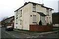
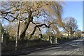
"The Rising Sun" falls
Closed pub on Jenkin Road, Brightside.
Image: © David Lally
Taken: 18 Nov 2010
0.00 miles
2
Tour de France 2014 Route - Jenkin Road, Brightside, Sheffield - 2
At this point the riders will be descending Jenkin Road, towards the view point,
in the knowledge that there is only a mile or two to go … and none of it up hill!
If the leader(s) are a long way ahead they could even make a slight detour to the nearby
Meadowhall Shopping Centre for a bit of retail therapy or a snack in the Food Court
UPDATE IN JUNE 2014
The finalised route has now been published, which confirms that the riders will ascending
Jenkin Road at this junction ... Not descending!
For a fuller description of the Cote de Jenkin Road … see …
Image
For more views of this site … see …
Image
Image
Image
For other views of Tour de France 2014 route …see …
Image
Image
Image
Image
Image
Image
… and follow the links from …
Image
Image: © Terry Robinson
Taken: 4 Feb 2014
0.01 miles
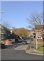
3
Eban Street, Brightside
The evocative smell of oiled steel was emanating from a company in the industrial units up the hill on the right.
Image: © David Lally
Taken: 18 Nov 2010
0.03 miles
4
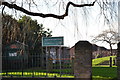
Brightside Recreation Ground, Jenkin Road, Brightside, Sheffield - 1
The Recreation Ground dates from around 1900 … originally had its own Park Keeper's Lodge
which was situated just behind the sign and in front of the steps … long since demolished.
Other sites seem to take much delight in telling us that the Park Keeper was a Mr Fidler.
See also …
Image
Image
Image
Image: © Terry Robinson
Taken: 4 Feb 2014
0.05 miles
5
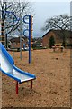
Slide and climbing frame with a view over the Don valley
In a small playground off Jenkin Road. Centre frame is one of the gable-end signs of Sheffield Forgemasters.
Image: © David Lally
Taken: 18 Nov 2010
0.05 miles
7
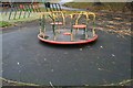
Playground roundabout
In a small playground off Jenkin Road.
This has a nostalgic meaning for me as a photograph of a previous roundabout which occupied this spot in 1981 was one of the first pictures that I took that I was really proud of.
Image: © David Lally
Taken: 18 Nov 2010
0.05 miles
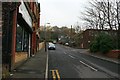
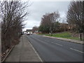
8
The view down Jenkin Road
Looking over the heavily industrialised Don Valley
Image: © David Lally
Taken: 18 Nov 2010
0.06 miles
9
Brightside Recreation Ground, Jenkin Road, Brightside, Sheffield - 3
Note the steepness of Jenkin Road … which will form part of Stage 2 of the Tour de France 2014 Route Fortunately at this point the riders will be going downhill! … see …
Image
See also …
Image
Image
Image
Image: © Terry Robinson
Taken: 4 Feb 2014
0.06 miles
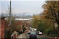
10
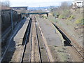
Brightside railway station (site), Sheffield
Opened in 1838 by the Sheffield & Rotherham Railway, this station closed in 1995. View south west towards Attercliffe Road and Sheffield.
Image: © Nigel Thompson
Taken: 27 Mar 2010
0.06 miles