IMAGES TAKEN NEAR TO
Sandstone Road, SHEFFIELD, S9 1AF
Introduction
This page details the photographs taken nearby to Sandstone Road, S9 1AF by members of the Geograph project.
The Geograph project started in 2005 with the aim of publishing, organising and preserving representative images for every square kilometre of Great Britain, Ireland and the Isle of Man.

There are currently over 7.5m images from over14,400 individuals and you can help contribute to the project by visiting https://www.geograph.org.uk
Image Map (Loading...)


Getting Data...Please wait
Leaflet Map data © OpenStreetMap
Images are licensed for reuse under creativecommons.org/licenses/by-sa/2.0
Notes
- Clicking on the map will re-center to the selected point.
- The higher the marker number, the further away the image location is from the centre of the postcode.
Image Listing (17 Images Found)
Images are licensed for reuse under creativecommons.org/licenses/by-sa/2.0
Image
Details
Distance
1
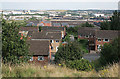
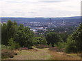
Housing above the Don Valley near Wincobank
The roofs of the Sheffield Forgemasters steelworks can be seen in the valley
Image: © Alan Murray-Rust
Taken: 5 Aug 2007
0.15 miles
2
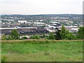
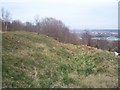
Wincobank - Fort
Behind the Fort, down in the Don valley, can be seen the Sheffield Forgemasters buildings, Sheffield Arena and Don Valley Stadium.
Image: © Dave Bevis
Taken: 25 May 2007
0.16 miles

4
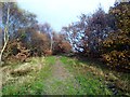
Wincobank, Iron Age Fort
A historic place to visit with Martin Richardson. Park on Jenkin Road or the narrow Fort Hill Road or easy at the end of Sandstone Avenue.
Name: Wincobank
Hill number: 16792
Height: 161m / 528ft
Parent (Ma/M): 2810 Black Hill
Section: 36: Lancashire, Cheshire & the Southern Pennines
County/UA: Sheffield (CoU)
Class: Tump (100-199m)
Grid ref: SK377910 (est)
Drop: 38m
Col: 123m SK343922
Image: © Rude Health
Taken: 22 Nov 2014
0.17 miles
6
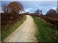
Roman Road
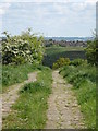
This track is often described as the 'remains of a Roman Road.' It was built during the Second World War as a means of taking equipment to the searchlight posts at the top of Wincobank Hill.
Image: © Dave Pickersgill
Taken: 16 May 2012
0.17 miles
8
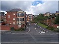
Holywell Heights
Holywell Heights, a new housing development.
Image: © Martin Speck
Taken: 19 Jul 2009
0.22 miles
9
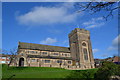
St Margaret's Church, viewed from Stupton Road, Brightside, Sheffield
Image: © Terry Robinson
Taken: 4 Feb 2014
0.23 miles
10
Wincobank Hill Fort
Wincobank hill fort showing the bank and ditch.
Image: © Martin Speck
Taken: 15 Mar 2009
0.23 miles