IMAGES TAKEN NEAR TO
Albert Road, SHEFFIELD, S8 9RD
Introduction
This page details the photographs taken nearby to Albert Road, S8 9RD by members of the Geograph project.
The Geograph project started in 2005 with the aim of publishing, organising and preserving representative images for every square kilometre of Great Britain, Ireland and the Isle of Man.

There are currently over 7.5m images from over14,400 individuals and you can help contribute to the project by visiting https://www.geograph.org.uk
Image Map (Loading...)


Getting Data...Please wait
Leaflet Map data © OpenStreetMap
Images are licensed for reuse under creativecommons.org/licenses/by-sa/2.0
Notes
- Clicking on the map will re-center to the selected point.
- The higher the marker number, the further away the image location is from the centre of the postcode.
Image Listing (55 Images Found)
Images are licensed for reuse under creativecommons.org/licenses/by-sa/2.0
Image
Details
Distance
1
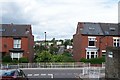
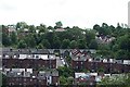
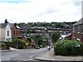
Kent Road, Meersbrook, Sheffield - 2
Taken from Argyle Close ... see ... Image ... for the opposite view. The 'Community Garden' area is more prominent in this view ... Image
Image: © Terry Robinson
Taken: 24 Jun 2012
0.07 miles
2
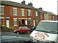
Terraced houses, Meersbrook, Sheffield
Image: © David Medcalf
Taken: 30 May 2004
0.10 miles
3
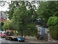
24 hour recovery
Vehicles in and out of a garden, Meersbrook, Sheffield.
Image: © Peter Barr
Taken: 28 Aug 2010
0.10 miles
4
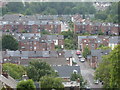
Kent Road, Meersbrook, Sheffield
A steep road, part of which has been closed off to traffic and converted into a community garden.
Image: © Peter Barr
Taken: 28 Aug 2010
0.11 miles
5
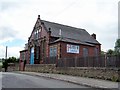
Henry Adams Memorial Hall, Kent Road, Heeley, Sheffield - 2
See also ... Image
Image: © Terry Robinson
Taken: 24 Jun 2012
0.11 miles
6
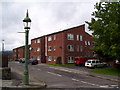
J.D. Cook and Beard Homes, Argyle Close, Meersbrook, Sheffield
Picture taken from the junction of Shirebrook Road and Kent Road ... see also ... Image Image Image Image Image
Image: © Terry Robinson
Taken: 24 Jun 2012
0.12 miles
7
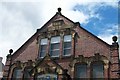
Henry Adams Memorial Hall, Kent Road, Heeley, Sheffield - 1
The date stone would indicate this building was opened in 1895 ... but in 1896 was known as Kent Road Chapel. Used by the Salvation Army at some stage ... now a Nursery ... see also ... Image
Image: © Terry Robinson
Taken: 24 Jun 2012
0.12 miles
8
Kent Road sewer gas lamp
A Webb Patent Sewer Gas Destructor Lamp on Kent Road at the junction with Nicholson Road. Many cities had these lamps. Sheffield had 84 of them installed between 1915 and 1935. At least 22 are known to have survived to modern times with many of them being listed.
Image: © Martin Speck
Taken: 17 Aug 2010
0.13 miles
9
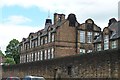
Carfield Primary School, Argyle Close, Meersbrook, Sheffield - 5
Image: © Terry Robinson
Taken: 24 Jun 2012
0.15 miles
10
Kent Road, Meersbrook, Sheffield - 1
Taken from the junction of Shirebrook Road and Kent Road ... the Cook and Beard Homes, on Argyle Close, are visible in the distance ... see ... Image ... but to get there you have to take a detour around the 'community garden area' visible mid picture. For a close up of this, see Peter Barr's picture Image ... See my picture ... Image ... for the opposite view.
Image: © Terry Robinson
Taken: 24 Jun 2012
0.16 miles