IMAGES TAKEN NEAR TO
Lees Hall Avenue, SHEFFIELD, S8 9JF
Introduction
This page details the photographs taken nearby to Lees Hall Avenue, S8 9JF by members of the Geograph project.
The Geograph project started in 2005 with the aim of publishing, organising and preserving representative images for every square kilometre of Great Britain, Ireland and the Isle of Man.

There are currently over 7.5m images from over14,400 individuals and you can help contribute to the project by visiting https://www.geograph.org.uk
Image Map
Images are licensed for reuse under creativecommons.org/licenses/by-sa/2.0
Notes
- Clicking on the map will re-center to the selected point.
- The higher the marker number, the further away the image location is from the centre of the postcode.
Image Listing (31 Images Found)
Images are licensed for reuse under creativecommons.org/licenses/by-sa/2.0
Image
Details
Distance
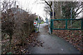
4
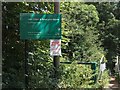
Entrance to Carr, Ashes and Coneygree Woods off Thorpe House Avenue
Image: © Neil Theasby
Taken: 2 Aug 2010
0.10 miles
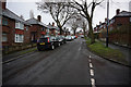
6
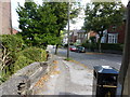
Bus stop, Upper Albert Road, Sheffield
An oak plank has been inset into this low garden wall for the benefit of those waiting for the bus; thoughtful, considering the steepness of these roads.
Image: © Peter Barr
Taken: 28 Aug 2010
0.12 miles
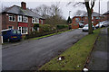
7
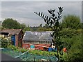
View of Allotments at Meersbrook/Carfield
Image: © Neil Theasby
Taken: 2 Aug 2010
0.12 miles