IMAGES TAKEN NEAR TO
Brook Road, SHEFFIELD, S8 9FH
Introduction
This page details the photographs taken nearby to Brook Road, S8 9FH by members of the Geograph project.
The Geograph project started in 2005 with the aim of publishing, organising and preserving representative images for every square kilometre of Great Britain, Ireland and the Isle of Man.

There are currently over 7.5m images from over14,400 individuals and you can help contribute to the project by visiting https://www.geograph.org.uk
Image Map
Images are licensed for reuse under creativecommons.org/licenses/by-sa/2.0
Notes
- Clicking on the map will re-center to the selected point.
- The higher the marker number, the further away the image location is from the centre of the postcode.
Image Listing (49 Images Found)
Images are licensed for reuse under creativecommons.org/licenses/by-sa/2.0
Image
Details
Distance
1
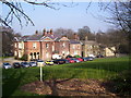
Meersbrook House
Meersbrook House was built 1780 by Benjamin Roebuck, a wealthy private Sheffield banker. The present day Meersbrook Park originally formed the grounds of the house. The house became the home of the Shores, owners of a bank on Church Street. When this bank crashed the house was auctioned in 1850. In 1890 the house was opened as the Ruskin Museum, which was formerly at St George’s Museum, Ruskin House, on Bell Hagg Road, Walkley. The Ruskin Collection, known officially as the Collection of the Guild of St George remained at Meersbrook House until until the 1950's. Parts of the Guild’s collection is now displayed in the Ruskin Gallery in Sheffield’s Millennium Galleries.Meersbrook House is now used by Sheffield Council Parks and Countryside Ranger Service. The Francis Firth Collection have a picture of the building (ref. 31971) showing the building as it was in 1893. http://www.francisfrith.com/sheffield/photos/ruskin-museum-1893_31971/ Sheffield Local Studies Library also have several pictures of this building, such as image number S05828. http://www.picturesheffield.com/index.html
Image: © Martin Speck
Taken: 15 Mar 2012
0.04 miles

3
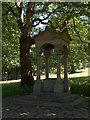
Victorian drinking fountain (disused) in Meersbrook Park
Drinking fountain, now disused. Dated 1891. Erected by the
Society of United Oddfellows in memory of William Westran.
Made by AJ & S Eaton of Intake. Ashlar and pink granite.
Eclectic style. Square canopy with entablature, pediment and
acroteria, carried on 4 round granite columns with foliage
capitals, moulded bases and square pedestals. Between them,
steps. Under the canopy, a square block with chamfered top and
inscription, formerly carrying the fountain.
Image: © Neil Theasby
Taken: 16 Jun 2010
0.09 miles
4
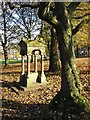
Westran Fountain, Meersbrook Park, Sheffield
I last photographed this historic drinking fountain in June 2010. See http://www.geograph.org.uk/photo/1917345
Image: © Neil Theasby
Taken: 11 Nov 2016
0.09 miles
5
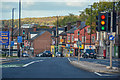
Sheffield : A61 Chesterfield Road
The lights are a little confusing here.
Image: © Lewis Clarke
Taken: 30 Sep 2018
0.10 miles

8

Close up, Elizabeth II postbox on Chesterfield Road
Postbox No. S8 311.
See Image] for wider view.
Image: © JThomas
Taken: 28 Jul 2016
0.13 miles
9

Elizabeth II postbox and phonebox on Chesterfield Road
Postbox No. S8 311.
See Image] for close up.
Image: © JThomas
Taken: 28 Jul 2016
0.13 miles