IMAGES TAKEN NEAR TO
Matthews Fold, SHEFFIELD, S8 8JT
Introduction
This page details the photographs taken nearby to Matthews Fold, S8 8JT by members of the Geograph project.
The Geograph project started in 2005 with the aim of publishing, organising and preserving representative images for every square kilometre of Great Britain, Ireland and the Isle of Man.

There are currently over 7.5m images from over14,400 individuals and you can help contribute to the project by visiting https://www.geograph.org.uk
Image Map (Loading...)


Getting Data...Please wait
Leaflet Map data © OpenStreetMap
Images are licensed for reuse under creativecommons.org/licenses/by-sa/2.0
Notes
- Clicking on the map will re-center to the selected point.
- The higher the marker number, the further away the image location is from the centre of the postcode.
Image Listing (68 Images Found)
Images are licensed for reuse under creativecommons.org/licenses/by-sa/2.0
Image
Details
Distance
2
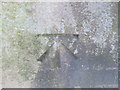
Ordnance Survey Cut Mark
This mark can be found on a gatepost in Matthews Lane.
For more detail see : http://www.bench-marks.org.uk/log?bm_key=46426
Image: © Peter Wood
Taken: 5 Dec 2012
0.06 miles
3
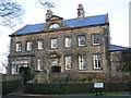
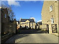
Norton Grange
An eighteenth century house altered and extended in the nineteenth century. http://www.britishlistedbuildings.co.uk/en-455861-norton-grange-and-adjoining-wash-house-s#.Vq096NCWOTw
Image: © Jonathan Thacker
Taken: 30 Jan 2016
0.07 miles
4
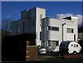
Norton Art Deco
Several houses in this area are Art Deco, next to "ordinary" 1930 semis.
Image: © Peter Barr
Taken: 28 Aug 2010
0.11 miles
6
Modernist houses, Cloonmore Drive
This pair is one of a number of such houses scattered among the conventional suburban semis of this part of Norton. They were designed by S. Garfield Mainwaring and built by M.J. Gleeson Ltd. and built in 1934/5.
Image: © Jonathan Thacker
Taken: 30 Jan 2016
0.12 miles
8
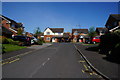
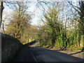
Norton Church Lane
Continues to the left but only as a footpath.
Image: © Jonathan Thacker
Taken: 30 Jan 2016
0.14 miles
9
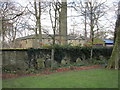
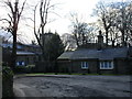
Norton, churchyard and Hall Stables
Image: © Jonathan Thacker
Taken: 30 Jan 2016
0.14 miles
10
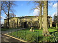
Stable block at Norton Hall
Dates from the late eighteenth century http://www.britishlistedbuildings.co.uk/en-455864-stable-block-200-metres-north-east-of-no#.Vq6dXNCWOTw
Image: © Jonathan Thacker
Taken: 30 Jan 2016
0.14 miles