IMAGES TAKEN NEAR TO
Matthews Lane, SHEFFIELD, S8 8JS
Introduction
This page details the photographs taken nearby to Matthews Lane, S8 8JS by members of the Geograph project.
The Geograph project started in 2005 with the aim of publishing, organising and preserving representative images for every square kilometre of Great Britain, Ireland and the Isle of Man.

There are currently over 7.5m images from over14,400 individuals and you can help contribute to the project by visiting https://www.geograph.org.uk
Image Map (Loading...)


Getting Data...Please wait
Leaflet Map data © OpenStreetMap
Images are licensed for reuse under creativecommons.org/licenses/by-sa/2.0
Notes
- Clicking on the map will re-center to the selected point.
- The higher the marker number, the further away the image location is from the centre of the postcode.
Image Listing (28 Images Found)
Images are licensed for reuse under creativecommons.org/licenses/by-sa/2.0
Image
Details
Distance
1
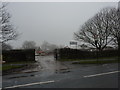
School site, demolition
Seven Hills School, Hemsworth Road site.
Image: © Peter Barr
Taken: 24 Jan 2012
0.07 miles
2
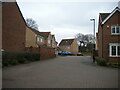
North end of Summerhouse Drive, Backmoor
Image: © Richard Vince
Taken: 28 Jan 2023
0.08 miles
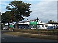
3
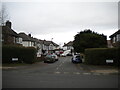
West end of Backmoor Crescent, Backmoor
Off Hemsworth Road.
Image: © Richard Vince
Taken: 28 Jan 2023
0.09 miles
5
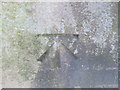
Ordnance Survey Cut Mark
This mark can be found on a gatepost in Matthews Lane.
For more detail see : http://www.bench-marks.org.uk/log?bm_key=46426
Image: © Peter Wood
Taken: 5 Dec 2012
0.09 miles
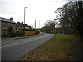
7
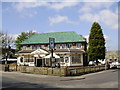
The New Inn, Hemsworth Road
This Public House incorporates a restaurant which is run under the name Ambers. It serves good value food.
Image: © Stephen Pointer
Taken: 18 Apr 2009
0.13 miles
8
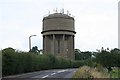
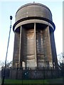
Norton Water Tower
I can't really believe I'm the first person to bag this square. Norton Water Tower is one of Sheffield's better known landmarks, situated high on one of the seven hills surrounding Sheffield. Once upon a time it used to be possible to take a trip up to the top of the tower, but I guess health and safety concerns, probably driven by the proliferation of communications antennae have put a stop to that pleasure.
Image: © David Morris
Taken: 26 Aug 2006
0.14 miles
9
Backmoor Summit
Martin Richardson's third County TUMP completion of the day so parked near the roundabout and walked up to and past the Norton water tower.
Name: Backmoor
Hill number: 16729
Height: 226m / 741ft
Parent (Ma/M): 2807 Kinder Scout
Section: 36: Lancashire, Cheshire & the Southern Pennines
County/UA: Sheffield (CoU)
Class: Tump (200-299m)
Grid ref: SK364824 (est)
Drop: 40m
Col: 186m SK350814
Image: © Rude Health
Taken: 22 Nov 2014
0.15 miles
10
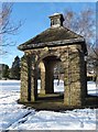
Almshouses' Pavilion
In the gardens of John Eaton's Almshouses, Norton, Sheffield
Image: © Neil Theasby
Taken: 3 Feb 2015
0.15 miles