IMAGES TAKEN NEAR TO
Batemoor Road, SHEFFIELD, S8 8FL
Introduction
This page details the photographs taken nearby to Batemoor Road, S8 8FL by members of the Geograph project.
The Geograph project started in 2005 with the aim of publishing, organising and preserving representative images for every square kilometre of Great Britain, Ireland and the Isle of Man.

There are currently over 7.5m images from over14,400 individuals and you can help contribute to the project by visiting https://www.geograph.org.uk
Image Map (Loading...)


Getting Data...Please wait
Leaflet Map data © OpenStreetMap
Images are licensed for reuse under creativecommons.org/licenses/by-sa/2.0
Notes
- Clicking on the map will re-center to the selected point.
- The higher the marker number, the further away the image location is from the centre of the postcode.
Image Listing (14 Images Found)
Images are licensed for reuse under creativecommons.org/licenses/by-sa/2.0
Image
Details
Distance
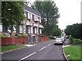
1
Houses at Batemoor Road's junction with Bowshaw Avenue
Image: © Neil Theasby
Taken: 21 Sep 2010
0.09 miles
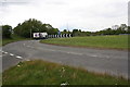
3
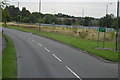
Sheffield : A61 Chesterfield Road South
A road heading into Sheffield.
Image: © Lewis Clarke
Taken: 30 Sep 2018
0.11 miles
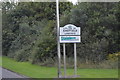
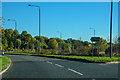
4
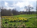
Greenhill Park
Greenhill Park by the A61.
Image: © Martin Speck
Taken: 4 Apr 2009
0.13 miles
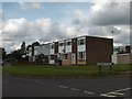
8
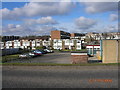
Batemoor Place
Local authority built housing on Batemoor Place.
Image: © Martin Speck
Taken: 30 May 2008
0.18 miles
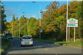
9
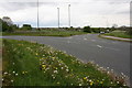
North East Derbyshire : A61 Chesterfield Road South
Heading off the roundabout on the A61.
Image: © Lewis Clarke
Taken: 1 Oct 2018
0.21 miles