IMAGES TAKEN NEAR TO
Lowedges Crescent, SHEFFIELD, S8 7LH
Introduction
This page details the photographs taken nearby to Lowedges Crescent, S8 7LH by members of the Geograph project.
The Geograph project started in 2005 with the aim of publishing, organising and preserving representative images for every square kilometre of Great Britain, Ireland and the Isle of Man.

There are currently over 7.5m images from over14,400 individuals and you can help contribute to the project by visiting https://www.geograph.org.uk
Image Map
Images are licensed for reuse under creativecommons.org/licenses/by-sa/2.0
Notes
- Clicking on the map will re-center to the selected point.
- The higher the marker number, the further away the image location is from the centre of the postcode.
Image Listing (24 Images Found)
Images are licensed for reuse under creativecommons.org/licenses/by-sa/2.0
Image
Details
Distance
1
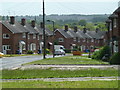
Lowedges Drive
A zoom shot from Lowedges Road of this residential street at the edge of the Sheffield conurbation.
Image: © Andrew Hill
Taken: 24 May 2011
0.10 miles
2
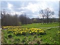
Greenhill Park
Greenhill Park by the A61.
Image: © Martin Speck
Taken: 4 Apr 2009
0.10 miles
4
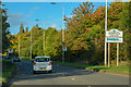
Sheffield : A61 Chesterfield Road South
A road heading into Sheffield.
Image: © Lewis Clarke
Taken: 30 Sep 2018
0.14 miles
5

Lowedges Road
Looking east showing position of Postbox No. S8 785.
Image: © JThomas
Taken: 28 Jul 2016
0.17 miles
6

Elizabeth II postbox on Lowedges Road
Postbox No. S8 785.
Image: © JThomas
Taken: 28 Jul 2016
0.17 miles

8

Houses, Lowedges
Junction of Lowedges Road / Lupton Road
Image: © JThomas
Taken: 28 Jul 2016
0.18 miles

10

Bus stop and shelter on Lowedges Road
Looking east.
Image: © JThomas
Taken: 28 Jul 2016
0.19 miles