IMAGES TAKEN NEAR TO
Firbeck, WORKSOP, S81 8LF
Introduction
This page details the photographs taken nearby to S81 8LF by members of the Geograph project.
The Geograph project started in 2005 with the aim of publishing, organising and preserving representative images for every square kilometre of Great Britain, Ireland and the Isle of Man.

There are currently over 7.5m images from over14,400 individuals and you can help contribute to the project by visiting https://www.geograph.org.uk
Image Map
Images are licensed for reuse under creativecommons.org/licenses/by-sa/2.0
Notes
- Clicking on the map will re-center to the selected point.
- The higher the marker number, the further away the image location is from the centre of the postcode.
Image Listing (7 Images Found)
Images are licensed for reuse under creativecommons.org/licenses/by-sa/2.0
Image
Details
Distance
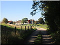
1
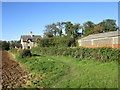
Bridleway and Thwaite House Farm Cottages
Larger farms often had cottages for the labourers at a discret distance from the farmhouse itself. Most are now occupied by non-farm workers.
Image: © Jonathan Thacker
Taken: 2 Oct 2015
0.02 miles
2
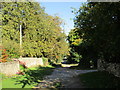
Lane leading to Thwaite House Bridge
Image: © Jonathan Thacker
Taken: 2 Oct 2015
0.03 miles
3
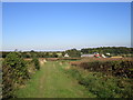
Bridleway and Thwaite House Farm
Thwaite House Farm Cottages in the very centre of the picture, Thwaite House Farm a little to the right. Larger farms often had cottages for the labourers at a discrete distance from the farmhouse itself. Most are now occupied by non-farm workers.
Image: © Jonathan Thacker
Taken: 2 Oct 2015
0.04 miles
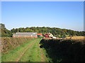
5
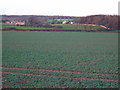
Across to Thwaite House
From the church path looking across to Thwaite House farms.
Image: © John Poyser
Taken: 10 Jan 2007
0.05 miles
7
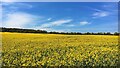
Field of gold and sky of blue
Beside Penny Hill
Image: © Graham Hogg
Taken: 26 Apr 2021
0.13 miles