IMAGES TAKEN NEAR TO
Lindrick Common, WORKSOP, S81 8BZ
Introduction
This page details the photographs taken nearby to S81 8BZ by members of the Geograph project.
The Geograph project started in 2005 with the aim of publishing, organising and preserving representative images for every square kilometre of Great Britain, Ireland and the Isle of Man.

There are currently over 7.5m images from over14,400 individuals and you can help contribute to the project by visiting https://www.geograph.org.uk
Image Map
Images are licensed for reuse under creativecommons.org/licenses/by-sa/2.0
Notes
- Clicking on the map will re-center to the selected point.
- The higher the marker number, the further away the image location is from the centre of the postcode.
Image Listing (7 Images Found)
Images are licensed for reuse under creativecommons.org/licenses/by-sa/2.0
Image
Details
Distance
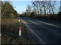
1
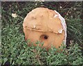
Old Milestone, on the A57, between Worksop and South Anston
Located on the North side of road, Lindrick Common, near Beware Horses sign. Stone post (plate lost), 18th century.
Inscription reads: (SHEFFIELD / 14 / WORKSOP / 4)
Milestone Society National ID: YS_SFWS14
Image: © Christine Minto
Taken: 5 Jan 2006
0.11 miles
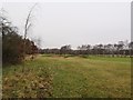
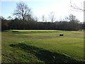
2
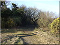
Track (footpath) into woodland, Lindrick Common
Off the A57.
Image: © JThomas
Taken: 7 Mar 2015
0.13 miles
4
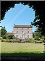
Lindrick House
Early 19th century Grade II listed building - "Deeply-coursed, squared limestone, pantile roof. 3 storeys, 3bays. Central French Window in ashlar door surround. All other bays with later iron casements in plain ashlar surrounds, the upper-floor windows linked by sill bands, the central 1st-floor window with iron-railed balcony.
Image: © Neil Theasby
Taken: 1 Aug 2013
0.16 miles