IMAGES TAKEN NEAR TO
Valley Road, WORKSOP, S81 7EJ
Introduction
This page details the photographs taken nearby to Valley Road, S81 7EJ by members of the Geograph project.
The Geograph project started in 2005 with the aim of publishing, organising and preserving representative images for every square kilometre of Great Britain, Ireland and the Isle of Man.

There are currently over 7.5m images from over14,400 individuals and you can help contribute to the project by visiting https://www.geograph.org.uk
Image Map
Images are licensed for reuse under creativecommons.org/licenses/by-sa/2.0
Notes
- Clicking on the map will re-center to the selected point.
- The higher the marker number, the further away the image location is from the centre of the postcode.
Image Listing (12 Images Found)
Images are licensed for reuse under creativecommons.org/licenses/by-sa/2.0
Image
Details
Distance
1
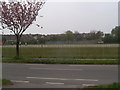
Running Track, Valley Road, Worksop
Similar position of previous image, taken when land was still in use as a running track in April 2005. The cherry blossom trees are a feature of Valley Road at that time of year.
Image: © Tim Hallam
Taken: 24 Apr 2005
0.02 miles
2
Valley School
A school bus has arrived early for home time
Image: © Chris Morgan
Taken: 18 May 2015
0.13 miles
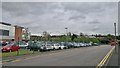
3
Former site of running track, Valley School
This is very much 'work in progress,' showing the present building site for the new Valley school, where there has been a running track until the beginning of May 2006. In the distance, you can see the council allotments, the main entrance of which are on Gateford Road.
Image: © Tim Hallam
Taken: 13 May 2006
0.15 miles
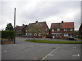
4

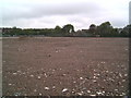
Valley Road, Worksop
Please refer to my previous 2 images of the transformation of the former Valley School running track. Much street furniture has appeared along this stretch of road in the last 2 years and an additional zebra crossing...oh, did I mention there's a whole new school too! At the time of this picture, glass has just been put into some of the windows of the new structure.
Image: © Tim Hallam
Taken: 25 Jan 2007
0.15 miles

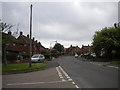
6
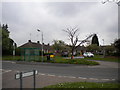
Bus stop and bungalows, Prince Charles Road, Worksop
The bus stop is located opposite Royal Crescent (left foreground), on a small island in the mouth of the short and apparently unnamed road that serves the bungalows in the background.
Image: © Richard Vince
Taken: 21 May 2013
0.18 miles
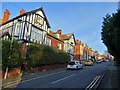
7
Southern end of Prince Charles Road, Worksop
Prince Charles Road heads west a short distance from Valley Road before turning north for the majority of its length. The bend begins about here, at the junction with Royal Crescent (left foreground).
Image: © Richard Vince
Taken: 21 May 2013
0.20 miles
8
Baulk Lane
Motor vehicles and cycles prohibited according to the sign, but this is surely facing the wrong way?.
Image: © Graham Hogg
Taken: 18 May 2015
0.20 miles
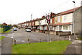
10
Small cul de sac off Prince Charles Road, Worksop
Looking along a short residential cul de sac (which appears not to have its own name) towards Prince Charles Road. Note the marked car parking spaces on the pavement, presumably implemented as a cheaper alternative to widening the road and narrowing the pavements.
Image: © Richard Vince
Taken: 21 May 2013
0.23 miles