IMAGES TAKEN NEAR TO
Gateford Close, WORKSOP, S81 7DR
Introduction
This page details the photographs taken nearby to Gateford Close, S81 7DR by members of the Geograph project.
The Geograph project started in 2005 with the aim of publishing, organising and preserving representative images for every square kilometre of Great Britain, Ireland and the Isle of Man.

There are currently over 7.5m images from over14,400 individuals and you can help contribute to the project by visiting https://www.geograph.org.uk
Image Map
Images are licensed for reuse under creativecommons.org/licenses/by-sa/2.0
Notes
- Clicking on the map will re-center to the selected point.
- The higher the marker number, the further away the image location is from the centre of the postcode.
Image Listing (12 Images Found)
Images are licensed for reuse under creativecommons.org/licenses/by-sa/2.0
Image
Details
Distance
1
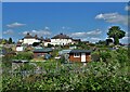
View over allotments at Gateford, Worksop
Image: © Neil Theasby
Taken: 27 May 2022
0.11 miles
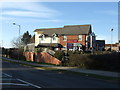
2
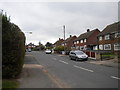
Windsor Road, Worksop
This short residential road between Prince Charles Road (behind the photographer) and Gateford Road is one of several in this part of Worksop named after royal residences.
Image: © Richard Vince
Taken: 21 May 2013
0.17 miles
3
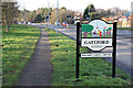
Gateford village sign
Design created by local schoolchildren based on local Roman finds. Gateford is now a suburb of Worksop.
Image: © Alan Murray-Rust
Taken: 20 Jan 2015
0.17 miles
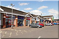
4
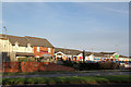
Roman's Rest and Celtic Point
Pub and retail development at Gateford.
Image: © Alan Murray-Rust
Taken: 20 Jan 2015
0.17 miles
5
Roman's Rest, Gateford
A new pub / restaurant.
Image: © JThomas
Taken: 7 Mar 2015
0.17 miles
6
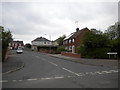
Clarendon Drive, Worksop
A short residential road between Prince Charles Road (foreground) and Gateford Road.
Image: © Richard Vince
Taken: 21 May 2013
0.18 miles
7
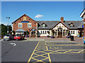
Romans Rest
New pub/diner at Gateford
Image: © Richard Croft
Taken: 22 Aug 2011
0.19 miles
8
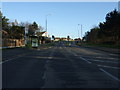
Gateford Road (B6041)
Heading south east into Worksop.
Image: © JThomas
Taken: 7 Mar 2015
0.19 miles
9
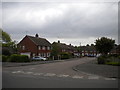
North end of Sandringham Crescent, Worksop
Sandringham Crescent is one of several roads off Prince Charles Road which are named after royal residences. While the houses lining it are apparently more pleasant than the flats in Image, it is still perhaps an inappropriate naming scheme for a council estate.
Image: © Richard Vince
Taken: 21 May 2013
0.20 miles