IMAGES TAKEN NEAR TO
Camping Lane, SHEFFIELD, S8 0HN
Introduction
This page details the photographs taken nearby to Camping Lane, S8 0HN by members of the Geograph project.
The Geograph project started in 2005 with the aim of publishing, organising and preserving representative images for every square kilometre of Great Britain, Ireland and the Isle of Man.

There are currently over 7.5m images from over14,400 individuals and you can help contribute to the project by visiting https://www.geograph.org.uk
Image Map
Images are licensed for reuse under creativecommons.org/licenses/by-sa/2.0
Notes
- Clicking on the map will re-center to the selected point.
- The higher the marker number, the further away the image location is from the centre of the postcode.
Image Listing (32 Images Found)
Images are licensed for reuse under creativecommons.org/licenses/by-sa/2.0
Image
Details
Distance
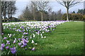
3
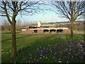
Towards the entrance to Hutcliffe Wood Crematorium
Image: © Andrew Tatlow
Taken: 3 Jan 2013
0.04 miles
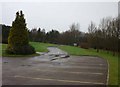
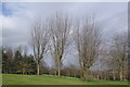
4
Stand of Trees
At Hutcliffe Wood Crematorium
Image: © John Jennings
Taken: 8 Mar 2012
0.10 miles
7
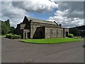
The chapel of rest in Abbey Lane Cemetery
Image: © Neil Theasby
Taken: 15 Aug 2019
0.14 miles
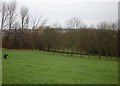
8

Bolt Concrete Block Marriott Woods Millhouses Allotments
On the footpath behind Millhouses Allotments
Image: © Monica Stagg
Taken: 1 Feb 2015
0.17 miles
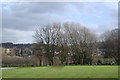
9
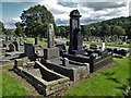
Graves in Abbey Lane Cemetery
The imposing black granite grave contains the remains of Gertrude and William Henry Hardcastle. She died in 1935. He died in 1940.
Image: © Neil Theasby
Taken: 15 Aug 2019
0.17 miles
10
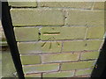
Cut Mark 2 Holmhirst Close Sheffield
as above
Image: © Monica Stagg
Taken: 13 Mar 2015
0.19 miles