IMAGES TAKEN NEAR TO
Longcroft View, WORKSOP, S80 4QT
Introduction
This page details the photographs taken nearby to Longcroft View, S80 4QT by members of the Geograph project.
The Geograph project started in 2005 with the aim of publishing, organising and preserving representative images for every square kilometre of Great Britain, Ireland and the Isle of Man.

There are currently over 7.5m images from over14,400 individuals and you can help contribute to the project by visiting https://www.geograph.org.uk
Image Map
Images are licensed for reuse under creativecommons.org/licenses/by-sa/2.0
Notes
- Clicking on the map will re-center to the selected point.
- The higher the marker number, the further away the image location is from the centre of the postcode.
Image Listing (43 Images Found)
Images are licensed for reuse under creativecommons.org/licenses/by-sa/2.0
Image
Details
Distance
1
Old Green Close, Whitwell
A recently built cul de sac off Hangar Hill.
Image: © Richard Vince
Taken: 17 Feb 2024
0.07 miles
2
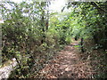
Path alongside Worksop Road
Most OS maps show the footpath from Whitwell Wood to Worksop Road, Whitwell as running directly to the road but in fact when it meets the road it turns right and runs parallel to it and above it for some 100 metres.
Image: © Jonathan Thacker
Taken: 22 Aug 2015
0.08 miles
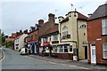
3
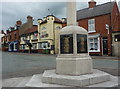
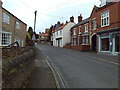
High Street, Whitwell, and the war memorial
Looking to the High Street from the war memorial, with a couple of shops and the Boot and Shoe pub in view.
Image: © Andrew Hill
Taken: 10 May 2011
0.09 miles
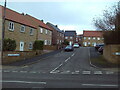
4
Eastern side of Hangar Hill, Whitwell
Seen from Welbeck Street, which continues west (left) as Hangar Hill into the centre of the village.
Image: © Richard Vince
Taken: 17 Feb 2024
0.09 miles
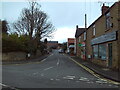
5
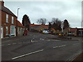
South end of High Street, Whitwell
On the north side of the Square, with Hangar Hill ahead.
Image: © Richard Vince
Taken: 17 Feb 2024
0.10 miles
7
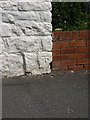
OS benchmark - Whitwell old Post Office
A cutmark in the brickwork of the former PO on the High Street. Originally levelled at 95.969m, 314'10" above Ordnance Datum Newlyn.
Image: © Richard Law
Taken: 8 Aug 2013
0.10 miles
8
"The Boot and Shoe", High Street, Whitwell
Image: © Neil Theasby
Taken: 26 Jun 2012
0.10 miles
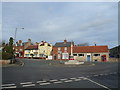
9
High Street, Whitwell
Looking towards the church, with the Square a short distance behind the photographer.
Image: © Richard Vince
Taken: 17 Feb 2024
0.11 miles
10
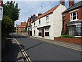
High Street, Whitwell
The white building is the former Post Office, into which Image is carved in the lower right corner.
Image: © Richard Law
Taken: 8 Aug 2013
0.11 miles