IMAGES TAKEN NEAR TO
Oxcroft Estate, Mansfield Road, WORKSOP, S80 4NA
Introduction
This page details the photographs taken nearby to Oxcroft Estate, Mansfield Road, S80 4NA by members of the Geograph project.
The Geograph project started in 2005 with the aim of publishing, organising and preserving representative images for every square kilometre of Great Britain, Ireland and the Isle of Man.

There are currently over 7.5m images from over14,400 individuals and you can help contribute to the project by visiting https://www.geograph.org.uk
Image Map
Images are licensed for reuse under creativecommons.org/licenses/by-sa/2.0
Notes
- Clicking on the map will re-center to the selected point.
- The higher the marker number, the further away the image location is from the centre of the postcode.
Image Listing (7 Images Found)
Images are licensed for reuse under creativecommons.org/licenses/by-sa/2.0
Image
Details
Distance
1
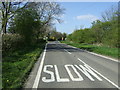
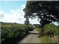
Slow on the B6417
Heading north towards Clowne.
Image: © JThomas
Taken: 18 Apr 2014
0.02 miles
5
Oxcroft seen from Damsbrook Farm
The dwelling visible in the centre of picture is prosaically titled 'Twenty Three Oxcroft Estate'.
Image: © Jonathan Clitheroe
Taken: 9 Aug 2014
0.22 miles
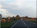
6
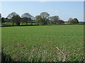
Crop field near Damsbrook Farm
Off Oxcroft Lane.
Image: © JThomas
Taken: 18 Apr 2014
0.23 miles
7
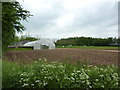
Polytunnel and vegetables growing
Market garden on Oxcroft Lane, between Stanfree and Elmton.
Image: © Peter Barr
Taken: 29 May 2012
0.24 miles