IMAGES TAKEN NEAR TO
St. Annes Close, WORKSOP, S80 3QS
Introduction
This page details the photographs taken nearby to St. Annes Close, S80 3QS by members of the Geograph project.
The Geograph project started in 2005 with the aim of publishing, organising and preserving representative images for every square kilometre of Great Britain, Ireland and the Isle of Man.

There are currently over 7.5m images from over14,400 individuals and you can help contribute to the project by visiting https://www.geograph.org.uk
Image Map
Images are licensed for reuse under creativecommons.org/licenses/by-sa/2.0
Notes
- Clicking on the map will re-center to the selected point.
- The higher the marker number, the further away the image location is from the centre of the postcode.
Image Listing (7 Images Found)
Images are licensed for reuse under creativecommons.org/licenses/by-sa/2.0
Image
Details
Distance
2
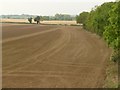
View from the bypass
The field has been tilled and rolled ready for seeding. The trees to the right mark the course of the River Ryton.
Image: © Alan Murray-Rust
Taken: 4 Oct 2015
0.17 miles
4
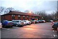
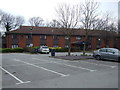
Travelodge, Worksop
A place to rest your head for the night, just off the Worksop bypass.
Image: © N Chadwick
Taken: 20 Dec 2008
0.20 miles
5
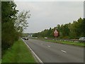
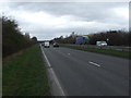
Worksop Bypass
Approaching the roundabout at Sandy Lane. The bypass was opened in 1986 and substantially relieved traffic through the town centre, the A57 being a major link from the A1 towards Sheffield.
Image: © Alan Murray-Rust
Taken: 4 Oct 2015
0.22 miles
6
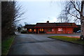
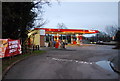
The Little Chef, Worksop
Just off the Worksop bypass.
Image: © N Chadwick
Taken: 20 Dec 2008
0.23 miles