IMAGES TAKEN NEAR TO
Clumber Park, WORKSOP, S80 3NX
Introduction
This page details the photographs taken nearby to S80 3NX by members of the Geograph project.
The Geograph project started in 2005 with the aim of publishing, organising and preserving representative images for every square kilometre of Great Britain, Ireland and the Isle of Man.

There are currently over 7.5m images from over14,400 individuals and you can help contribute to the project by visiting https://www.geograph.org.uk
Image Map
Images are licensed for reuse under creativecommons.org/licenses/by-sa/2.0
Notes
- Clicking on the map will re-center to the selected point.
- The higher the marker number, the further away the image location is from the centre of the postcode.
Image Listing (33 Images Found)
Images are licensed for reuse under creativecommons.org/licenses/by-sa/2.0
Image
Details
Distance
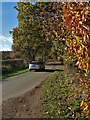
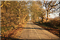
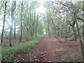
4
Normanton Larches
Tree-lined lane near Clumber Park
Image: © Richard Croft
Taken: 26 Nov 2010
0.07 miles
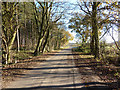
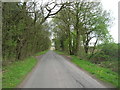
5
Normanton Larches
Leafy lane to Bothamsall at Normanton Larches
Image: © Richard Croft
Taken: 13 Dec 2012
0.11 miles
6
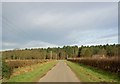
Robin Hood Way along West Drayton Avenue
After leaving Clumber Park, and crossing the busy A614, the Way enters Normanton Larches along an old road which used to connect Clumber House with West Drayton.
Image: © Tim Heaton
Taken: 14 Mar 2009
0.11 miles
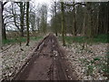
9
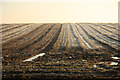
Frozen furrows
Frost on what looks like potato ridges at Normanton Larches
Image: © Richard Croft
Taken: 13 Dec 2012
0.13 miles
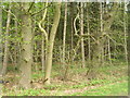
10
Robin Hood Way through Normanton Larches
Image: © John Slater
Taken: 4 Oct 2015
0.14 miles