IMAGES TAKEN NEAR TO
Gladstone Place, WORKSOP, S80 1RD
Introduction
This page details the photographs taken nearby to Gladstone Place, S80 1RD by members of the Geograph project.
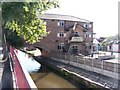
The Geograph project started in 2005 with the aim of publishing, organising and preserving representative images for every square kilometre of Great Britain, Ireland and the Isle of Man.

There are currently over 7.5m images from over14,400 individuals and you can help contribute to the project by visiting https://www.geograph.org.uk
Image Map
Images are licensed for reuse under creativecommons.org/licenses/by-sa/2.0
Notes
- Clicking on the map will re-center to the selected point.
- The higher the marker number, the further away the image location is from the centre of the postcode.
Image Listing (206 Images Found)
Images are licensed for reuse under creativecommons.org/licenses/by-sa/2.0
Image
Details
Distance
1
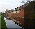
Factories beside the canal in Worksop
Cuckoo Way.
Image: © steven ruffles
Taken: 22 Nov 2011
0.03 miles
2
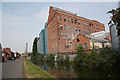
Albion Mill
Flour mill beside the Chesterfield Canal in Worksop
Image: © Richard Croft
Taken: 5 Jun 2010
0.04 miles
3
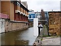
No access to the towpath
This locked gate is a bit of a surprise as you follow the Chesterfield Canal towpath through Worksop, but presumably it protects the boats moored beyond.
Image: © Christine Johnstone
Taken: 31 Mar 2010
0.04 miles
4
Pipe bridge across the Chesterfield Canal
Next to Canal Road in the centre of Worksop.
Image: © Mat Fascione
Taken: 22 May 2016
0.05 miles
5
Converted Canal Building - Worksop
Old warehouse nicely converted into restaurant and bar.
Image: © Colin Babb
Taken: 12 Sep 2009
0.05 miles
6
Canal Road, Worksop, Notts.
With the former straddle warehouse (a.k.a. "Pickford's Depository") behind the photographer, this is the view towards a T junction of Canal Road with Kilton Road. The Albion Mill, parts of which date from 1906, can be seen ahead on the opposite bank. The flour mill, which has its main (front) entrance on Eastgate, is currently owned by Whitworth Bros. of Wellingborough. The Chesterfield Canal originally covered a distance of 46 miles (or 74 km) from the River Trent at West Stockwith, Nottinghamshire to Chesterfield, Derbyshire. Currently 31.6 miles (or 50.9 km) of the canal is navigable in two unjoined stretches.
Image: © David Hallam-Jones
Taken: 8 Sep 2016
0.05 miles
7
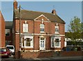
Grafton House
Dated 1814 in the pediment, this is an attractive early 19th century double-front house. (The bay windows are later 19th century.) Listed Grade II.
Image: © Alan Murray-Rust
Taken: 4 Oct 2015
0.06 miles
8
Canal Road
Road by the Chesterfield Canal through Worksop
Image: © Richard Croft
Taken: 5 Jun 2010
0.06 miles
9
Old warehouse crane
This canal-side area was once the private wharf associated with the Straddle warehouse.
Image: © Christine Johnstone
Taken: 31 Mar 2010
0.06 miles
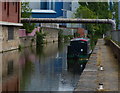
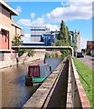
10
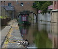
Chesterfield Canal in Worksop
The narrowboat is moored near the Straddle Warehouse.
Image: © Mat Fascione
Taken: 22 May 2016
0.06 miles