IMAGES TAKEN NEAR TO
Oaks Farm, BARNSLEY, S75 5SA
Introduction
This page details the photographs taken nearby to Oaks Farm, S75 5SA by members of the Geograph project.
The Geograph project started in 2005 with the aim of publishing, organising and preserving representative images for every square kilometre of Great Britain, Ireland and the Isle of Man.

There are currently over 7.5m images from over14,400 individuals and you can help contribute to the project by visiting https://www.geograph.org.uk
Image Map
Images are licensed for reuse under creativecommons.org/licenses/by-sa/2.0
Notes
- Clicking on the map will re-center to the selected point.
- The higher the marker number, the further away the image location is from the centre of the postcode.
Image Listing (24 Images Found)
Images are licensed for reuse under creativecommons.org/licenses/by-sa/2.0
Image
Details
Distance
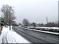
1
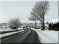
Darton Lane B6131
Looking towards Darton.
Image: © John Fielding
Taken: 6 Jan 2010
0.13 miles
2
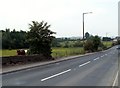
Darton Lane
Adjacent to old Pumber Pit.
Image: © John Fielding
Taken: 8 Jun 2007
0.14 miles
3
Old Pumber Pit entrance from the B6131
The pic was taken from the junction.
Image: © John Fielding
Taken: 2 Feb 2009
0.14 miles
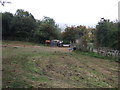
4
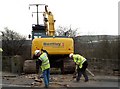
A tight squeeze
Darton Lane at the entrance to old Pumber Pit site, the crawler excavator just squeezes through the gap. It will make its way along the old railway to the new school in Darton where an old mine shaft has appeared in the grounds, this is the only way it can be reached.
Image: © John Fielding
Taken: 25 Feb 2008
0.14 miles
5

Obstruction on B6131 Darton Lane
At the entrance to Old Pumber Pit see pallets in pic, the crawler excavator is about to be unloaded and driven through the gap.
Image: © John Fielding
Taken: 25 Feb 2008
0.15 miles
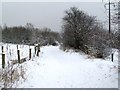
6

Snow Covered Oak Sapling
On old railway embankment.
Image: © John Fielding
Taken: 2 Feb 2009
0.17 miles
7
Grazing off Darton Lane
Near disused railway.
Image: © JThomas
Taken: 25 Sep 2013
0.17 miles
8
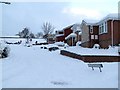
Not so sunny Sunningdale Avenue
Pic taken from the junction with St Andrews Drive.
Image: © John Fielding
Taken: 1 Dec 2010
0.18 miles
9
The B6131 Darton Lane
Right hand side beyond the wall is the Old Pumber Pit site.
Image: © John Fielding
Taken: 2 Feb 2009
0.19 miles
10
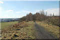
Disused railway line near Darton
An old colliery line; large areas of the landscape in this region have been shaped by the now-gone coal industry, nature is slowly reclaiming them.
Image: © Chris Yeates
Taken: 3 Mar 2006
0.19 miles