IMAGES TAKEN NEAR TO
Holme View Road, BARNSLEY, S75 5EP
Introduction
This page details the photographs taken nearby to Holme View Road, S75 5EP by members of the Geograph project.
The Geograph project started in 2005 with the aim of publishing, organising and preserving representative images for every square kilometre of Great Britain, Ireland and the Isle of Man.

There are currently over 7.5m images from over14,400 individuals and you can help contribute to the project by visiting https://www.geograph.org.uk
Image Map
Images are licensed for reuse under creativecommons.org/licenses/by-sa/2.0
Notes
- Clicking on the map will re-center to the selected point.
- The higher the marker number, the further away the image location is from the centre of the postcode.
Image Listing (23 Images Found)
Images are licensed for reuse under creativecommons.org/licenses/by-sa/2.0
Image
Details
Distance
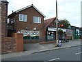
3
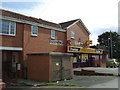
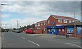
Convenience store on Ballfield Lane, Kexbrough
Image: © JThomas
Taken: 3 Oct 2014
0.15 miles
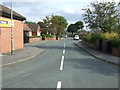
4
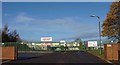
The entrance to Darton High School
On Upperfield Lane.
Image: © Steve Fareham
Taken: 15 Nov 2008
0.16 miles
5
Corner shop, Ballfield Lane, Darton
This looks to have expanded over the years, and the houses to the left of the shop and also the electricity transformer station are not yet on the currently viewable large-scale OS map.
Image: © Humphrey Bolton
Taken: 1 May 2008
0.17 miles
7
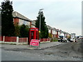
Corner of Cooper Road and Ballfield Lane, Kexbrough
A well-kept phone-box in this ex-mining village.
Image: © Jonathan Billinger
Taken: 19 Feb 2009
0.17 miles
8
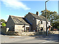
Old cottage, Churchfield Lane, Kexborough
There is an 18th century datestone on the building (the actual date wasn't readable in my photo).
Image: © Stephen Craven
Taken: 17 Oct 2019
0.18 miles
10
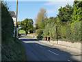
Churchfield Lane, Kexborough
Looking west, the name becomes Upper Field Lane at some point along here.
Image: © Stephen Craven
Taken: 17 Oct 2019
0.18 miles