IMAGES TAKEN NEAR TO
Upperfield Lane, BARNSLEY, S75 5EB
Introduction
This page details the photographs taken nearby to Upperfield Lane, S75 5EB by members of the Geograph project.
The Geograph project started in 2005 with the aim of publishing, organising and preserving representative images for every square kilometre of Great Britain, Ireland and the Isle of Man.

There are currently over 7.5m images from over14,400 individuals and you can help contribute to the project by visiting https://www.geograph.org.uk
Image Map
Images are licensed for reuse under creativecommons.org/licenses/by-sa/2.0
Notes
- Clicking on the map will re-center to the selected point.
- The higher the marker number, the further away the image location is from the centre of the postcode.
Image Listing (10 Images Found)
Images are licensed for reuse under creativecommons.org/licenses/by-sa/2.0
Image
Details
Distance
3
Cowcroft Farm between the trees.
Photo taken from A637 Huddersfield Road.
Image: © John Fielding
Taken: 8 May 2007
0.23 miles
4
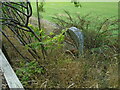
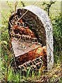
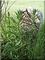
Old milestone
Another view of the poor old West Riding CC milestone behind the fence, hidden in vegetation on the A637, Park Hill, north of Darton. This style of milestone dates from 1893/94 when 615 were set up all over the old West Riding.
Image: © Chris Minto
Taken: 7 Aug 2022
0.24 miles
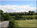
5
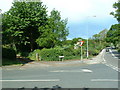
Junction of Ballfield Lane and the Huddersfield Road (A637)
Image: © Nigel Homer
Taken: 4 Jun 2006
0.24 miles
6

Old Quarry
near the junction of Ballfield Lane and the Huddersfield Road, Kexbrough
Image: © Nigel Homer
Taken: 4 Jun 2006
0.24 miles
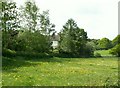
7
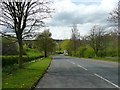
Ballfield Lane, Kexbrough, Darton
Looking down towards the A637.
Image: © Humphrey Bolton
Taken: 1 May 2008
0.24 miles
8
Milestone in Darton, Barnsley
Milestone on the A637 between Darton and Haigh in Barnsley.
It has some damage.
Image: © matthew lovett
Taken: 29 Apr 2020
0.24 miles
9
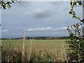
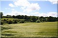
Field north of Upper Field Lane
The field is quite a bit higher than the lane.
Image: © Christine Johnstone
Taken: 9 Sep 2011
0.25 miles
10
Old Milestone by the A637, Huddersfield Road
Metal plate attached to stone post by the A637, in parish of BARNSLEY (BARNSLEY District), Huddersfield Road between Darton and junction 38 of the M1, behind fence part way up hill from Darton, above footpath sign, on West side of road. Brayshaw & Booth iron casting, erected by the County Council in the 19th century.
Inscription reads:-
: HUDDERSFIELD / 12¼ MILES / BRETTON / 2½ MILES : : BARNSLEY & (GRANGE MOOR) / RO(AD) / KEXBOROUGH : : BARNSLEY / 4 MILES :
Hole in top.
Maker:-
: BRAYSHAW & BOOTH / MAKERS / LIVERSEDGE. :
Grade II Listed. List Entry Number: 1151767
https://historicengland.org.uk/listing/the-list/list-entry/1151767
Milestone Society National ID: YS_BNHU04.
Image: © C Minto
Taken: 1 Dec 2001
0.25 miles